Major Coastal Flooding Possible in New England on Saturday
- Tim Dennis
- Jan 11, 2024
- 3 min read
Updated: Jan 12, 2024
Another multi-hazard storm is on the way to New England. Among the top concerns with this storm will be the threat of moderate to potentially major coastal flooding. In general, the highest threat for significant coastal flooding will be along the northern New England coast, but there is a threat of some coastal problems in southern New England as well. Here's a look at what's currently forecast:

NORTHERN NEW ENGLAND
Coastal flooding similar to what was seen on Wednesday morning could once again play out near the Saturday high tide, which will occur around noon for most. The peak surge of 2.5 to 3.5 feet is currently looking to occur a few hours before high tide. This timing is similar to Wednesday morning. A difference with Saturday is that tides will be astronomically higher. This has the potential to be a historic high tide for Maine and possibly New Hampshire.
Scenes from New Hampshire and Maine Wednesday morning:
Credits: Henry's Weather Channel, WGME, Bristol Parks and Recreation
If this timing and maximum surge comes to be reality, it would create widespread moderate coastal flooding with pockets of major coastal flooding across New Hampshire and Maine. Even small changes in peak surge and timing will result in significantly different impacts, for better or worse. We need to watch the trends closely, especially as they begin to play out Saturday morning.
At this point, Hampton, New Hampshire and Portland, Maine are forecast to reach major flood stage. Portland, Maine saw its third highest tide on record on Wednesday when a preliminary crest of 13.84 feet occurred. As of Thursday evening, the forecast crest is 14.3 feet, which would surpass the Blizzard of 78's 14.1 feet and set a new all-time record.
Hampton, New Hampshire, which saw its highest tide since records have been kept there (records only date back to 2012 for Hampton), when the tide reached 13.67 feet. This created widespread flooding of homes, businesses and roads. The current forecast for Hampton has the tide reaching 13.7 feet.
Heading further north into downeast Maine, a surge of up to 4 feet will come close to astronomical high tide. The National Weather Service of Caribou is stating this is the highest threat of coastal flooding across downeast Maine in a decade. All-time records could be threatened in Bar Harbor, Cutler and Eastport, according to the National Weather Service of Caribou.

Numerous roads near the coast will likely be closed and/or damaged. Homes, businesses and other structures and cars could be flooded with some damage occurring. Some evacuations in the most vulnerable areas could happen and significant beach erosion is likely, especially after the damage that occurred on Wednesday.
Expected wind direction and potential wind gusts at 10am Saturday (1st image) and noon Saturday (2nd image):
SOUTHERN NEW ENGLAND
Based on current timing, the east coast of Massachusetts would fare the best on Saturday, with minor flooding forecast from Newburyport through Boston through Provincetown. Peak surge is currently expected closer to low tide in these areas. Areas of southern New England that may see moderate coastal flooding would be the south coast, where the peak surge will likely occur closer to high tide.
These moderate flooding areas include Narragansett Bay at Fox Point, Conimicut Point and Quonset Point, RI; New Haven, CT; New London, CT and Stamford, CT. These areas will likely closures of shoreline roads for the few hours around high tide as well as flooding of parking lots, parks and low-lying structures.

Like northern New England, timing will be key when it comes to the extent of coastal flooding. The degree of impacts will come down to when the strongest winds occur in relation to the astronomical high tide.
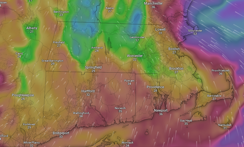
Expected wind direction and potential wind gusts at 10am Saturday (1st image) and noon Saturday (2nd image):
CONCLUSION
This storm will have the chance to create a significant coastal flooding event similar to Wednesday. A potentially historic tide is possible across Maine. Coastal flood warnings are in effect from Maine through northern Massachusetts and from Cape Cod through eastern Connecticut. Coastal flood advisories are in effect for Metro Boston and Plymouth county as well as western Connecticut.


Comments