Showers, Thunderstorms Return to New England Wednesday
- Tim Dennis
- May 7, 2024
- 3 min read
After one more dry and warm day, New England will be entering a rather prolonged period of cloudy and showery weather. This will begin on Wednesday with the arrival of an area of low pressure to New England. This system will lift a warm front across southern New England in the morning to early afternoon hours, bringing with it a shield of rain. The system's cold front will be pulled across New England later on Wednesday. This will lead to a cloudy, showery day with some thunderstorms.

Showers will break out across southwestern New England likely before or around sunrise and push northeast through the morning. By mid-morning, the showers will have reached just about all of New England outside of Maine. With deep moisture ahead of the showers, they will likely become heavy at times. There will also be a chance for some rumbles of thunder.
HRRR showing expected weather around mid-morning Wednesday:

Heading into the mid-afternoon, a "dry" slot works into New England while the initial batch of rain continues for Maine. We put dry in quotes since this slot likely won't actually be fully dry, but rather showers will become more isolated and generally lighter in the afternoon east of Maine. There will be more dry times than wet times after noon for much of New England.
NAM showing expected weather around early-afternoon Wednesday:

Much of New England will likely see a quarter to a half inch of rain from this initial batch of showers for the week. The highest amounts will generally be across northwest areas with totals dropping as you head south and east.
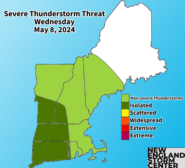
Heading later into the afternoon, things may get interesting. A few thunderstorms may develop across southern and central New England as CAPE (convective available potential energy) values increase. Areas of western New England may see values increase to 500+ joules/kilogram, which would support thunderstorms as well as a chance for isolated strong storms.
GFS forecast CAPE values around 4pm. Areas colored in blue and green will likely see values climb to 400+, which can be favorable for thunderstorms:

Other ingredients for storms will also be present, with an ample amount of shear and moisture available. The level of instability will be a major limiting factor as sunshine in the afternoon will be hard to come by. The atmosphere may not be able to recover much from the morning's round of rain. If western New England (particularly Connecticut, western Massachusetts and southern Vermont) can see at least some sun break through the clouds, chances for storms will become higher.
NAM showing expected weather mid to late afternoon. You can see some storms trying to form across western areas. Not all models are on board with storms firing, which is a testament to the potential lack of instability:

Overall, the threat of strong to severe thunderstorms is on the lower end, but the ingredients will be present, so it will be something to watch in the afternoon. If storms are able to develop, one or two could become strong, with small hail and gusty winds being the primary threat.

As we've been advertising for several days now, the rest of the week will be cloudy and showery with multiple waves of low pressure moving through New England. Temperatures will also be on a cooling trend rough Friday, when temperatures hit rock bottom. Highs Friday are looking to be in the 50s region-wide. Highs may struggle to get to 50°in the higher elevations and along the coast.
Forecast rainfall from now through Sunday morning:


Comments