Temperatures to Rise as Quickly as They Fell Heading Into the New Week
- Tim Dennis
- Feb 24, 2024
- 3 min read

Temperatures Saturday afternoon will not rise more than a few degrees from morning lows as strong cold air advection continues from an area of high pressure to the northwest. Wind chills Saturday afternoon will range frompot the single digits below zero north to the teens south as blustery conditions will prevail.

This brief chill that has now settled in will peak Sunday morning with lows in the single digits north to low teens south. Continued wind chills will drop the feels-like temperature into the -10s, close to -20° in the higher elevations of northern New England with single digits south. This will be some of the coldest air of the season, which really isn't saying much as arctic blasts have been lacking this winter.
Winds will quickly begin to relax as Sunday goes on with rapid warming during the day. This comes as high pressure builds to our west, allowing a southwesterly flow to send mild air into New England. As quickly as the colder air comes, it will disappear.

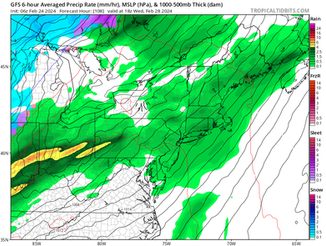
Heading into Monday, a weak area of low pressure will pass to New England's north. This system will drag a warm across the area Monday, leading to some scattered and light rain or snow showers, mainly in northern New England. The system's weakening cold front won't have an impact on the overall warming trend.

The warmth will continue to build through mid-week as a ridge in the jet stream builds into the east. This, along with a southerly flow, will allow temperatures to climb well above average. A trough of low pressure will cross the country during the week. This will eventually bring a period of rain and potentially gusty winds to New England.

The warmth will build through the first half of the week with Monday, Tuesday and Wednesday each a notch warmer than the previous day. By Tuesday, widespread 50s will be likely across southern New England with 40s and nearing 50° in spots in northern New England. By Wednesday, widespread 50s across all of New England is looking increasingly likely.
As of now, Tuesday is looking like a mainly dry day and both Monday and Tuesday should feature partly to mostly cloudy skies. That area of low pressure on the map above will move north of New England by mid-week. While timing can still shift at this range, it looks like Wednesday and/or Wednesday night will be the focus for rainfall.

This overall setup supports widespread rainfall and a period of stronger winds. While it remains much too early to go into exact rainfall amounts, it does appear that the system will be progressive, which would help keep amounts lower, with many areas showing less than an inch.
As for the winds, as usual, there will be factors working for and against stronger wind gusts. Confidence will be highest in strongest wind gusts near the coast, the question will become just how far inland the winds can push.
Model roundup (Euro, GFS, CMC and GraphCast) for Wednesday afternoon:


After this system, a cool-down is very likely as the cold front gets dragged across the region. Just how cool (or cold) it gets in its wake is to be determined. What is certain about next week is that New England will be losing plenty of snowpack (where there even is a snowpack). Snow depth is running below average for not only New England, but all of the United States.
This isn't a surprise as this winter was expected to feature a strong El-Nino setup. These setups favor less cold air and lower than average snowfall across much of the north, and that's what has generally played out this winter. We'll go more in-depth into this aspect in an article tomorrow (Sunday).
Snow depth as of February 24 in the United States and zoomed in on New England:


The warmer weather may hang around for the most part. We don't typically bring up the Climate Prediction Center's 3-4 week outlook very often due to how many small-scale factors that can derail the forecast(which can still happen in this case), but there is an exceptionally high amount of confidence in generally above average temperatures at this time frame. As always when we show the 3-4 week outlook, take it with a grain of salt (no matter the confidence level).


Comments