A Blockbuster Snowstorm Struck New England's Neighbor This Past Weekend
- Tim Dennis
- Feb 6, 2024
- 3 min read
At the start of February, an area of low pressure passed to New England's north. This storm dropped 5-8 inches of snow in northern Maine before continuing its journey eastward. After exiting Maine, the storm slowed to a crawl thanks to a large-scale blocking pattern over North America. By Friday, February 2, the storm had stalled and continued to spin to the south of Nova Scotia.
Over the past 72 plus hours, bands of heavy snow and strong winds have cycled through Nova Scotia. This has dropped a total of three to four feet of snow in places, with a storm maximum of 59 inches (150cm). This stalled storm has finally begun the process of exiting the region. This storm stalled just too far east of New England to bring us widespread snowfall.

The hardest hit area of Nova Scotia was Cape Breton, where one observer in Sydney measured nearly five feet of snow. Strong winds created blizzard conditions on Cape Breton and across Nova Scotia, this has led to snow drifts much higher than the reported total snowfall. The island has declared a state of emergency. The heavy snowfall smashed through the windows of apartment buildings in the area.
It will likely be days before all roads across the province are clear. The region's largest city, Halifax, saw varying amounts of snow across the metro area. The Halifax-Stanfield International Airport picked up just under three feet of snow. This has led to the deepest snowpack on record at the airport.
Photo credits: Made In Canada; Same Old Nobody/X; Andre LeBlanc; Tom Ayers
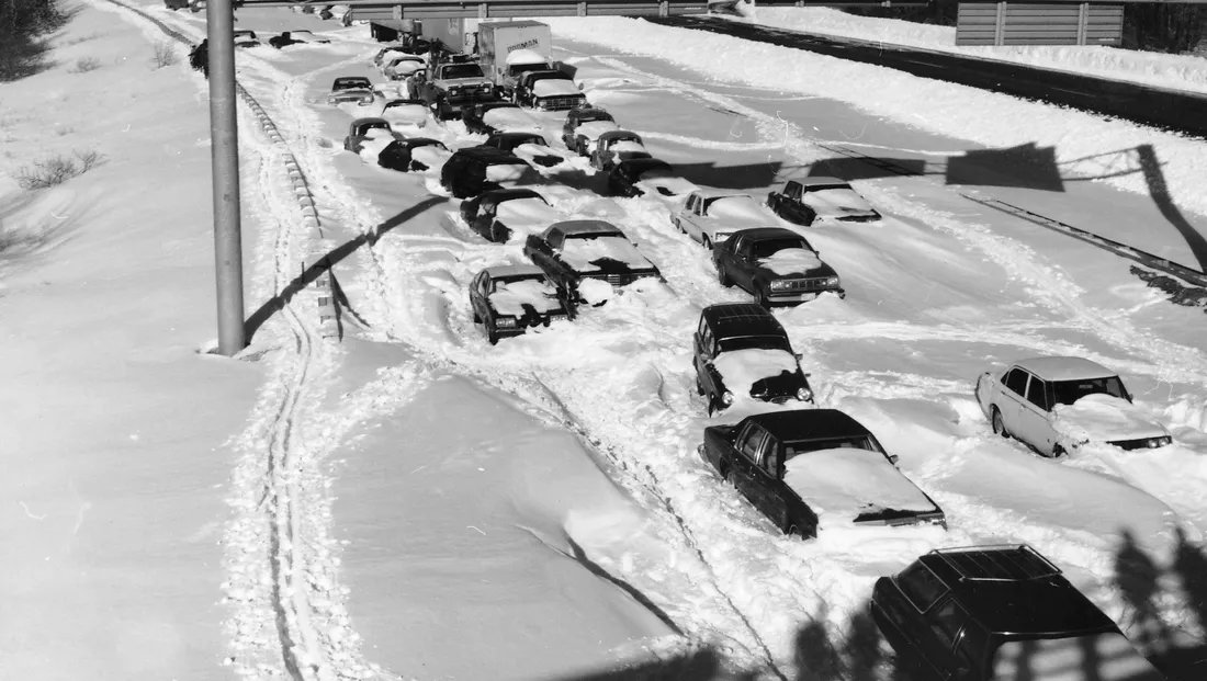
On Monday, Cape Breton Regional Police reported over 550 service calls over the weekend as well as "many many many stranded motorists and abandoned vehicles." This all comes around the 46th anniversary of New England's Blizzard of 1978, which was headlined by abandoned vehicles on highways and a days-long plowing effort.
Images from the Blizzard of '78 in New England:
The Blizzard of 1978's likely maximum snowfall is around the 40" mark. This is one of at least six snowstorms to drop at least 40" on New England. The most snow from a single storm in New England likely came during the Great White Hurricane of 1888. We list the maximum snowfall at 50", although being a major blizzard in the 1800s, we'll never truly know the exact amounts.
In the past few years, two non-blizzard nor'easters dropped over 40" on parts of New England. In 2020, a nor'easter dropped 48" on Danbury, New Hampshire and just last year, a similar nor'easter dropped 42" on Readsboro, Vermont.
Nova Scotia's blizzard easily surpassed all of these looking at maximum snowfall. If this blocking pattern was set up just a bit differently, this post could have been talking about a blockbuster New England blizzard rather than a blockbuster Nova Scotia Blizzard.
The following image shows a graphic we used in an article published on Friday, showing the overall setup for this past weekend. This setup helped clear active weather out of New England as our region sat on the edge between a ridge to the west and a trough to the east.

If New England sat in the center of the trough, the low pressure system (seen just east of Nova Scotia) would have stalled closer to New England, with eastern New England, particularly Maine, likely digging out big time. Should-a, could-a, would-a. You can thank high pressure to the west and north for keeping New England dry.
Looking ahead at New England's weather, a storm will remain well out to sea Tuesday and Wednesday, staying far enough away to avoid any impacts. Another system will lift to the north of New England on Friday, dragging a warm front across the region. This could touch off some scattered showers and bring very mild air into New England.

Things will cool back off after the weekend thanks to a cold front. We'll be watching for a storm system to impact New England early next week, possibly on Monday or Tuesday. Depending on how everything shakes out, this storm could bring some snow to parts of New England.
Weather map for Tuesday morning (February 13):


Comments