Another Summer is Drawing to a Close in New England: A Look Back
- Tim Dennis
- Sep 9
- 4 min read

Just like that, meteorological summer has drawn to a close and we're quickly racing toward the official start of fall. While the end of the summer went out with a whimper when it comes to summer heat, much of this summer saw stretches of intense heat and humidity across the region. Overall, this summer ended up being pretty variable with temperatures. Stretches of big heat and humidity were replaced by cooler weather before a new round of heat came into play. In the end, the back-and-forth for temperatures sort of canceled each other out, with the summer as whole ending up only slightly above average for most.

New England's warmest city relative to average was Burlington, Vermont, which ended meteorological summer 1.5° above average. This was the city's sixth warmest summer on record. Concord, New Hampshire was the only other city to see a top 10 warmest summer. Boston, Hartford, Portland and Caribou all came within 0.5° of historical summer averages, with Portland being the only one to fall on the cooler side, at -0.1°.
Just like last summer, the region's first real heat wave of the summer season ended up being the most intense. Also similar to last year, this heat came in the form of a heat dome that set up toward the end of June. The heat lasted multiple days, but peaked on June 24th, when cities across the region in all six states climbed toward, or over, the century mark. Boston reached 102°, setting a new all-time June record. That reading was 2° shy of the city's all-time record of 104°, set on the Fourth of July 1911. Providence, Portland and Augusta all set New June high temperatures as well.

As stated at the beginning, the end of summer once again went out with a whimper. While southern New England saw a mostly cooler August from start to finish, northern New England saw a rather warm start to the month before finishing cool. This is seen best looking at Burlington. On August 15th, the city was running nearly 2.5° above average. The city would end August a half of a degree below average. In the final two weeks of August, the city's average temperature dropped a full 2°.
Unlike previous summers, this one wasn't overly wet and did not include multiple major flash flooding events. There was one notable event that brought impactful flooding to Vermont and Massachusetts. On July 10th, a widespread 3-6 inches of rain fell from a strip extending across northern Rhode Island through Boston's southern suburbs in the morning, causing widespread street flooding during the morning commute in New England's most heavily populated area.
Below: Flooding on Interstate 93 just south of Boston on July 10th:

Later in the day, the same complex brought scattered thunderstorms to Vermont. Unfortunately, these storms were much slower-moving than expected, which led to flash flooding being the primary impact. Incredibly, for the third July 10th in a row, a portion of Vermont saw significant flooding and damage. The floods in Vermont were much more isolated than the previous two years, limited to several communities in the Northeast Kingdom. Significant road damage, bridge washouts, evacuations and rescues all took place as a thunderstorm stalled for hours around Burke and Sutton, Vermont.
Below: flooding in the Sutton, Vermont area on July 10th:

Overall, this was a drier summer for New England, with all major climate sites recording less than 100% of typical rainfall. Portland and Boston came in as the driest, with both cities seeing 50% or less of typical rainfall. This was Portland's sixth driest summer on record. August in particular was nearly bone dry, especially for northern New England. This has allowed for drought conditions to re-develop after eliminating the start of the year's drought. A wide swath of northern New England has been put into severe drought status.
Below: Current US drought status. This map does not include this past weekend's rainfall as the map is updated weekly on Thursdays:

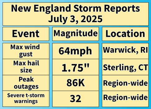
Another shift from the past couple summers was a generally quieter severe weather season. Both 2023 and 2024 saw a good handful of severe weather and tornado events. This summer saw rather long stretches between stormy days with widespread severe weather days few and far between. With that said, there were a few severe weather days. July 3rd saw over 30 severe thunderstorm warnings and nearly 90,000 power outages, leaving thousands in the dark for the holiday. Hail up to the size of golf balls fell in parts of the region.
Below: Stats for New England's notable severe weather events this summer:


Outside of these events, a significant microburst occurred in central New Hampshire on July 20th. The town of Sanbornton saw maximum winds of 105mph out of this storm. The storm was about a half mile wide and damaged or destroyed over 500 trees within the town. 105mph is equivalent to a high-end EF1 tornado.
Speaking of tornadoes, this meteorological Summer was notably absent of them. We began keeping track of all New England tornadoes since 2008 and this was the first summer since then not to see a tornado touchdown in June through August. It had been over a year since New England's last tornado on July 16th, 2024. Despite the rarity of a tornado in any one given community in New England, it is rather uncommon to go this long without one somewhere in the region. For perspective, the last calendar year to go tornado-free in New England was 1952.
Of course, 2025 will not go tornado-free as the National Weather Service has confirmed at least three tornadoes to have touched down this past Saturday. These tornadoes have all been rated EF1 and all came within a short time-frame of each other. The same storm seemingly dropped all of the tornadoes. If a tornado lifts off the ground and quickly touches back down, it counts as two. These tornadoes occurred in Holden, Paxton, Berlin and Stow, Massachusetts. The National Weather Service has not yet released their final report on these tornadoes as of writing Tuesday morning.


Comments