New England Weather This Week: It's Mid-October
- Tim Dennis
- Oct 13
- 3 min read

This week will begin with rainy and breezy weather. After that, pretty typical mid-fall weather will be in the air for the rest of the week.
MONDAY
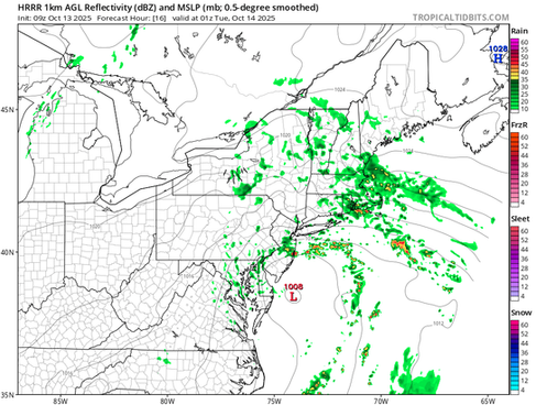
The center of the nor'easter will remain hung up around the southern New Jersey coastline throughout the day today. The easterly flow around this system, along with strong upper-level flow, will continue to push bouts of rain across New England from east to west today. Rain will continue to be most widespread across southern New England, particularly eastern areas. Showers will likely continue to become more and more scattered as the day goes on from north and west to south and east.
An additional 1-2 inches of rain is expected over eastern Massachusetts and Rhode Island. 0.25 to 0.75 inches is expected over the rest of New England through Tuesday morning. High pressure will remain over the crown of Maine today, which will limit rainfall in Maine to the Greater Portland area. Other parts of the state are expected to remain dry today.

As of Monday morning, just over 16,000 are without power across New England, with 10,000 out in Connecticut alone. Winds will continue to be mainly a coastal threat, with gusts of 50-50mph continuing. Breezy conditions will continue throughout the day inland, with gusts of 20-30mph. A low-level jet will gradually diminish through the day and into the overnight hours, which will gradually lower winds.

Today will likely be a washout for southern New England, with scattered showers continuing to cycle through northern areas. Rain will gradually break up as the day goes on and we move into the evening hours. With that said, damp and showery weather will likely persist for eastern Massachusetts and Rhode Island into Tuesday morning.
Below: HRRR showing potential weather around mid-afternoon today (1st image) and this evening (2nd image):


TUESDAY
The nor'easter will remain offshore of New England on Tuesday. In this blocking pattern, it will be slow to exit eastward throughout the day. While the rain will lighten up and become lighter and more drizzly in nature, thanks mainly to a weakening low-level jet, it will likely remain cloudy over eastern areas. Some pokes of sun will be possible later in the day for western areas. As this storm gradually loosens its grip on New England, temperatures will begin to rise slightly. Highs in the mid 50s to mid 60s are expected region-wide.

WEDNESDAY-FRIDAY
Wednesday will likely be the warmest day of the week, but it will still be right around seasonal averages. A moisture-starved cold front will push into the region through the day, so the flow ahead of this front will bring the milder temperatures before things come back down behind the front. This front truly is moisture-starved, with little to no shower activity likely as it crosses. Any activity is most likely across the northern tier and mountains.
Once this front passes, a cooler air mass will settle over New England for Thursday and Friday as Canadian high pressure sets up to the west of the region. The pressure gradient on Thursday will likely be rather tight with the high to the west and Monday's nor'easter hanging near Nova Scotia. This will make Thursday blustery and will add to the chill in the air. Depending on how close the nor'easter gets pulled back toward the west, some showers will be possible for coastal New England on Thursday.
Below: Temperature departure from average on Thursday afternoon:

Overall, midweek and late week look to generally be influenced by a large-scale trough over New England with ridging remaining farther to New England's west. This will help promote the cooler temperatures and possibly allow for a subtle system or two to move through the region, bringing clouds and maybe a couple showers at times.
WEEKEND
This upcoming weekend could potentially look similar to this past weekend. Ridging looks to nudge further into New England on Saturday, leading to a nice and dry mid-fall weekend day. The return of ridging over troughing will promote a continued warm-up, with widespread 60s expected at this time.
A frontal system looks to approach early next week. At this time, the system looks to remain across the Great Lakes region this weekend and impact New England with another round of wet weather more toward next Monday. With that said, the upper-level pattern is rather uncertain beyond mid-week, so trends will be watched in regards to this system.
Below: Current weather map for this upcoming Sunday (October 19):


Comments