SLIM: The Four Ingredients for Severe Thunderstorms Explained
- Tim Dennis
- Apr 25, 2024
- 4 min read
The formation of severe thunderstorms can hinge on the highly used acronym S.L.I.M., which stands for Shear, Lift, Instability and Moisture. While there are many factors that go into thunderstorm development, these four ingredients are vital to determining the threat level of a potential severe thunderstorm or tornado outbreak.

SHEAR
While lift, instability and moisture are necessary components to get thunderstorm activity, shear is the main component that can propel a thunderstorm into becoming a severe thunderstorm. Wind shear comes in two types, and both help create severe storms in different ways.
Speed shear occurs when winds are moving at different speeds in different altitudes. This allows the storm to become a "tilted updraft". Tilted updrafts see rain fall ahead of the updraft, which can allow storms to strengthen instead of weaken as the cool, falling air is ahead of the warm, rising air.
Example of a tilted updraft (right) vs a non-tilted one (left):

While speed shear can help ignite the possibility of tornadoes, directional shear is what will really kick-start rotating supercells. Directional shear occurs when winds are moving in different directions in different altitudes.

When there is a combination of speed and directional shear, a severe weather outbreak is on the table. In areas that are favored to see tornadic activity, a tornado outbreak will be possible. This is, of course, if the other ingredients are also present.
LIFT
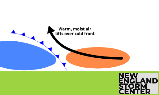
Lift is what allows thunderstorm development in the first place. A mode of lift is needed to force moist and unstable air up into the atmosphere. As this air cools, it condenses into clouds. There are multiple modes of lift that can occur. In New England, lift for thunderstorms often comes in the form of frontal. As a cold front pushes through New England, the warm, moist air in place ahead of the front is pushed up and over the cool, dry air behind the front.
The first image shows the cold front acting as a lift mode. The second image is a model run from August 18, 2023 showing storms firing along a cold front:
Other modes of lift include convergence (when winds around an area of low pressure come together), orographic (when winds run into terrain, such as a mountain, and are forced to rise over the mountain; this is another common mode of lift in New England among the mountains in the north) and convectional (which comes from uneven heating of the ground during the day).
INSTABILITY
Instability is basically the tendency for the warm air that has been lifted (using one of the modes above) to accelerate as it continues to move upwards. The Instability of the atmosphere is measured by looking at the vertical temperature profile, or lapse rate.
In a stable environment, the temperature gradually and consistently falls with altitude (or temporarily increases with height before falling again; this is called an inversion, which can help prevent thunderstorm growth). In an unstable environment, the temperature will fall rapidly with height; this is known as steep lapse rates.
The level of instability in the atmosphere can be calculated. This is called convective available potential energy (CAPE). CAPE is measured in joules/kilogram. The higher the CAPE value, the more unstable the atmosphere is and the more primed for thunderstorm development. Typically, CAPE values in excess of 1,000 joules/kilograms are considered a favorable atmosphere for severe thunderstorms, however, CAPE values of even a few hundred can at least trigger thunder within showers.
The first image shows forecast CAPE values on April 25, 2024. The second image shows the Storm Prediction Center's thunderstorm outlook for the day. You can see the correlation between the highest CAPE values and where the SPC has highlighted for the risk of severe weather:
MOISTURE
Moisture is the fuel that feeds thunderstorms. The moisture in the atmosphere is measured looking at dew points. Generally, the higher the dew point, the stronger and more widespread thunderstorms can get.
In the summertime, New England's dew points can often get well into the 60s, indicating a humid or muggy atmosphere. A dew point of 60° is generally considered to be the threshold needed for strong storms to develop. This is typically the point that most people will be able to feel the humidity when outside.

TRIPLE POINT LOW
While there are many setups that can lead to strong to severe thunderstorms and potentially tornadoes, one in particular is the formation of a triple point low. A triple point is where the three basic types of fronts attached to an area of low pressure meet. These frontal boundaries are a warm front, cold front and occluded front.
Since cold fronts typically move faster than warm fronts, the cold front can overtake the warm front. Where this happens, an occluded front emerges. Sometimes, a secondary area of low pressure can form at the point where these three fronts meet. This area can check all the boxes for thunderstorms.
The area has plenty of moisture in the warm sector of the system, the approaching cold front and low pressure provides the lift, the low pressure can also prove the instability and wind shear is common in these areas as the winds wrap around the triple point.
The following is a general example of a triple point over New England. This setup could lead to soaking rain and strong thunderstorms:


