A Closer Look at Lee's Coastal Flood Threat Across New England
- Tim Dennis
- Sep 15, 2023
- 3 min read
The primary concern with Hurricane Lee's passing for most of New England is coastal flooding and pounding surf. You can see a detailed Lee forecast covering all aspects of the storm here. Here's a look at what to expect in New England's coastal areas, working from south to north:
CONNECTICUT & RHODE ISLAND
A coastal flood advisory is in effect from 7pm Friday to 5am Sunday for Connecticut. Minor coastal flooding and splashover will be possible. An offshore flow and protection from Long Island will shield the coast from much of the effects of Lee. 1 to 2 feet of surge is possible in the most vulnerable areas. This represents a "worst case scenario." New England's south coast should fare the best out of New England's coastline. A high surf advisory is in effect for Rhode Islands from now through 8pm Sunday.
CAPE COD & THE ISLANDS
A coastal flood warning is in effect from midnight Friday night through 2pm Saturday for Cape Cod and Nantucket. Martha's Vineyard is under a coastal flood advisory due to lesser impacts expected. For the Cape and Nantucket, 1 to 2 feet of storm surge is possible. This will result in scattered minor to minor-moderate flooding.
Numerous roads near the shoreline are likely to be inundated and closed. Low lying properties will also likely become flooded. Very large, pounding waves will cause beach erosion. Breaking waves near 30 feet are possible in the surf zone. The 1am high tide is the biggest concern due to the wind direction, however, large pounding surf could also cause minor coastal flooding during the Saturday afternoon high tide. North facing beaches will face the biggest issues Saturday morning.
The areas with the greatest chance of issues will be Nantucket Harbor, Dennis-Sesuit Harbor and Sandwich Harbor.
Martha's Vineyard will be shielded from the worst of the coastal flooding during the 1am high tide thanks to the northerly flow. Still, isolated pockets of minor flooding may occur, primarily in Edgartown in Vineyard Haven.
NORTH & SOUTH SHORE
A coastal flood advisory is in effect from midnight Friday night to 2pm Saturday for the entirety of the Massachusetts shoreline outside of the Cape and Islands. Pockets of minor coastal flooding will be possible across the area with up to a half foot of surge during both the 1am and 1pm high tides.
The flow will be helpful for this area, especially during the Saturday afternoon high tide. However, the largest waves are expected during this cycle, so isolated minor flooding may still occur. Breaking waves up to 20 feet are expected in the surf zone. Beach erosion is likely to occur, with more north facing beaches bearing the brunt of the storm.
Minor coastal flooding is possible in Gloucester Harbor, Plum Island, Boston Harbor, Revere and Scituate.
NEW HAMPSHIRE SEACOAST THROUGH MAINE'S MIDCOAST
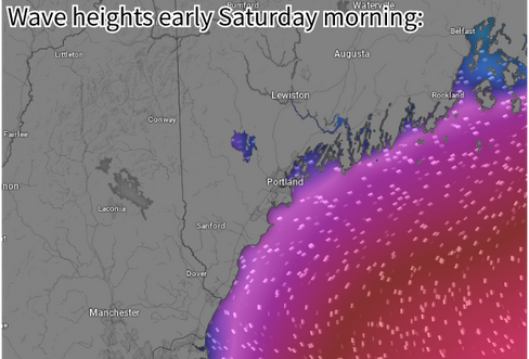
A coastal flood advisory is in effect from midnight Friday night through 2pm Saturday. Pockets of minor coastal flooding is possible from widespread and potentially significant splash over during both the early morning and early afternoon high tides. The biggest concern is the Saturday afternoon high tide.
The wind will be offshore during both high tides, however, waves will be massive and pounding the shoreline, causing splashover. Breaking waves of 12-18 feet are expected Saturday afternoon, with slightly smaller waves Saturday morning. This will also cause beach erosion across the area.
Minor coastal flooding is currently expected in Hampton, Portland and Boothbay Harbor.
DOWNEAST MAINE
A coastal flood warning is in effect from 11pm Friday night through 5pm Saturday. Pockets of moderate coastal flooding will be possible due to massive, pounding surf. The wind will be offshore during both the Saturday morning and Saturday afternoon high tide cycles, which will thankfully limit the flooding.
Despite this, significant splashover is expected, especially during the Saturday afternoon high tide. This may cause a storm surge of up to 3 feet. Road damage and widespread road closures are expected along the coastline. Large rocks are expected to crash onto shoreline roads, plows are expected to be pulled out to clear these rocks after the storm.
Minor to moderate coastal flooding is expected in Machias, Mount Desert Island, Schoodic Point, Deer Isle, Lubec and Eastport. The flood threat has diminished for areas up the Penobscot River toward Bangor.


Comments