Breaking Down Thunderstorm Chances For Monday, Tuesday For New England
- Tim Dennis
- Jul 3, 2023
- 3 min read
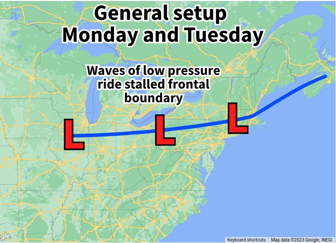
New England's low pressure parade rolls on through the fourth of July as a stalled frontal boundary sits right over southern New England. This front will allow multiple low pressure systems to slide across our region today and tomorrow, bringing rounds of storms and more chances for torrential downpours.

MONDAY
The main severe thunderstorm threat will remain south of New England this afternoon with Georgia through New Jersey expected to get the bulk of the action. Still, scattered thunderstorms will erupt in southern New England this afternoon, with isolated storms reaching strong to severe status.
The best chance for stronger storms will be southern Massachusetts, Connecticut and Rhode Island. The storms will be hit or miss this afternoon, so not everyone in southern New England will get a storm. The chances of seeing storms this afternoon diminish more and more the further north you go in the region, with the exception of the White Mountains, where storms are more likely. Storm chances increase overall in northern New England as we get into Monday night.

The primary threat in storms that fire in southern New England will be damaging wind gusts, small hail and torrential downpours leading to flash flooding. Storms that fire north of the Mass Pike are very unlikely to turn severe, however, torrential downpours could still occur in these storms.
Storms may begin firing as early as 2pm and continue firing through midnight. There are discrepancies in timing the main thunderstorm activity. The Euro Model shows storms erupting around mid-afternoon while HRRR shows more isolated storms firing mid-afternoon with the bulk of activity coming in around sunset. The main takeaway is that today will be unsettled and storms will likely be firing throughout the afternoon, through the evening and into the overnight hours.
Euro vs HRRR. Euro showing storms firing in southern New England around mid-afternoon while HRRR shows activity just beginning in southern New England at 7pm, with the White Mountains seeing more activity:
4TH OF JULY
It will stay unsettled through much of the night from Monday to Tuesday morning. There will likely be a break in the precipitation from mid to late morning for most. Afternoon thunderstorms on the 4th will be very similar to what occurred on Monday.

The main difference is that coverage will be pushed further north and overall coverage of the storms will likely be more widespread. The timing of the storms is also a bit earlier in the day, with the bulk of storms firing between 11am and 8pm.
The storms will again bring a chance for damaging winds and small hail, but the main threat will be torrential rainfall, causing flash floods. While nearly the entire region will have a chance to see flooding rains, the best chance of flash floods is in Connecticut, western Rhode Island and southwest Massachusetts.

The storms will begin to clear out around sunset, so 4th of July festivities may be able to go off on a dry note, but some showers will likely still be hanging around after 8pm, so be prepared! Lightning will also be a threat, so keep an eye to the sky if outside during the daytime.
BEYOND
New England will get a brief break from all this unsettled weather right as the holiday weekend wraps up. Wednesday and Thursday will feature partly cloudy to mostly sunny skies and summer-like heat, with highs jumping well into the 80s and perhaps 90s in some places. In this overall pattern, the threat of showers is never zero, and the White and Maine mountains could see some isolated showers pop up on both of these days.
Friday is looking warm as well, but rain will re-enter the picture in the afternoon as thunderstorms are looking to erupt. This will once again usher in a lot of clouds with daily shower and storm chances into the weekend along with cooler temperatures (although cooler in this case looks to see temps come back down to seasonable levels).
This overall unsettled pattern will stick with us until further notice.


Comments