Cold Nights End, Warming Trend Begins for New England
- Tim Dennis
- Apr 26, 2024
- 3 min read
The start of the weekend will be more of the same for New England with high pressure remaining in place. With the high overhead of New England to start off Saturday, it will be yet another cold night, though not as cold as the past two nights. During the day Saturday, the flow will turn more southwesterly, allowing temperatures to get a notch warmer than Thursday and Friday. Highs will be in the 60s for pretty much everyone except the immediate coast.
Clouds will likely begin to move into the region later on Saturday as our next system approaches. This system, along with its fronts, are weak. The system will pass to New England's north on Sunday, lifting its warm front across New England.

This front will lead to some scattered, light showers for Sunday morning. We need to put an emphasis on light and scattered as most areas will likely not see much more than a tenth of an inch of rain. The day will be a notch warmer than Saturday inside the warm sector of the system. The day will likely be mainly cloudy, but some clearing is possible in the afternoon. The extent of clearing will determine just how mild it gets on Sunday. Highs will likely top out in the 60s to low 70s.
CMC showing the potential for a line of showers Sunday morning:

There will generally be more clouds and shower chances across the north Sunday afternoon. This comes as weak energy continues to move across the north along with a weak cold front dropping into the area. This will keep shower chances going for the northern third of the region Sunday afternoon into Sunday night. It still won't be raining this entire time for this area.
CMC showing another round of scattered, light showers for Sunday night across the north:

In a turn of events that surprised no one, Monday has generally trended cooler for much of New England. With that said, it will still be on the milder side for most with highs pushing toward 70° for southern and central New England away from the coast as a ridge in the jet stream will allow a warmer air mass aloft into New England regardless of what happens at the surface.
This comes as the departing system pulls a weak cold front over New England, which will bring more clouds (though the day is not looking overcast) and a northerly flow. A sea breeze will also keep temperatures down near the coast. Any shot at scraping 80° will be limited to western Connecticut.
Euro showing feels-like temperatures for early Monday afternoon. You can see New England is generally mild, but summer weather is building just to the southwest (Baltimore will be pushing 90° on Monday and Tuesday!). A sea breeze will loom large along the coast:

The rest of next week is looking generally active, but unimpactful as a couple frontal systems move through New England. These will bring plenty of clouds and some showers, but, again, nothing major. This will begin on Tuesday with another frontal system bringing widespread showers to the area.
Weather map for Tuesday (April 30):

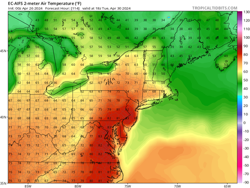
Temperatures next week are a tough call, especially for southern New England, but they may end up hanging around seasonable levels. Warmer weather will try to stick around for Tuesday through Thursday, but a persistent flow off the ocean will likely keep eastern areas cooler.
Traditional Euro model (1st image) and the Euro's new machine-learning model (2nd image) showing temperatures Tuesday afternoon. You can see the traditional model is more in on warmth in southern New England than its AI counterpart:


Comments