New England Weather This Week: Busy
- Tim Dennis
- 1 minute ago
- 4 min read
This week will feature a busy weather pattern with multiple systems moving through at a rapid fire pace. A brief break in the cold temperatures will come around midweek for some while others will get a shot at some snow.
MONDAY
Last night's quick-moving clipper system will slide across Nova Scotia this morning. This system has helped drag an Arctic cold front across the region, setting up another very cold day. Afternoon high temperatures will only rise a few degrees from morning lows, which will range from the single digits across the north country to the low 20s across southern and central New England.
High pressure will quickly begin to build into New England through the day. The gradient between the incoming high and departing low will create blustery winds, with gusts of 20-30mph. In the afternoon, as the low moves away and the high takes over, these winds will begin to subside.

TUESDAY
With high pressure moving directly over New England tonight and Tuesday morning, excellent radiational cooling conditions will be present. Continuously lightening winds, mostly clear skies and a snow pack will help temperatures bottom out. Morning lows will drop into the single digits, on either side of zero, for a majority of the region. The southern New England coastal plain may be the only part of New England that can hold onto double digits tonight.
Below: HRRR showing potential low temperatures Tuesday morning:

Through the day, high pressure will shift from being directly overhead to the east of New England. This will set up a weak southerly flow and warm air advection. The overall air mass remains cold, so a notable warm-up is not expected in the afternoon, but it should get a notch warmer than Monday afternoon as the latest Arctic blast begins to slowly retreat. Afternoon highs will remain sub-freezing region-wide.
Our rapid-fire weather pattern continues, with another clipper system zipping across the region from west to east Tuesday evening through Wednesday morning. This system will be weak, and with meager forcing, limited moisture and very fast nature, this system won't be able to put down much more than a dusting anywhere. This will mostly be a few scattered snow showers through the evening and nighttime.

WEDNESDAY
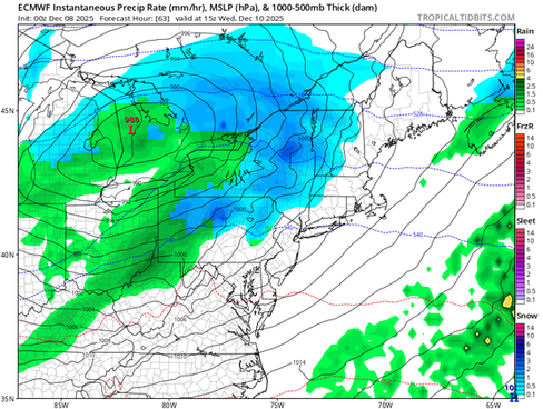
As quickly as the weak clipper system exits Wednesday morning, the next, more organized system, will move into the region. This system will involve an area of low pressure moving out of the Great Lakes and northeast across interior New England. The center of the system will likely push across New England near the Canadian border.
This makes the system an inside runner, with milder air getting pulled into eastern New England on a southerly flow. This will help initial snow and mixing transition to plain rain for southern New England and the northern New England coast. For interior northern New England, enough cold air will likely remain in place for all or mostly snow.

After the Tuesday night clipper system, the region will likely get a short break from precipitation (at least a few hours) before this one moves in. Precipitation chances will increase from west to east from the mid-morning hours Wednesday through the early afternoon. Precipitation will overspread northern New England first as the center of the system travels to the north.
When precipitation arrives, it may be cold enough for snow or mixing everywhere. This would be followed by a transition to rain from south and east to north and west during the afternoon. Should precipitation hold off until the afternoon for southern New England, temperatures will likely warm enough to start as rain.
Below: Euro showing potential weather around mid-morning (1st image) and mid-afternoon (2nd image):


Despite the low running well inland, thermal profiles will likely remain cold enough for the system to be all or mostly snow across interior New England. Helping the storm remain snow in these areas will be the fast-moving nature of the storm and the potential for a secondary low to form in eastern Maine, locking in colder air for the north. The timing of the system will be the biggest limiting factor for snowfall, with a widespread 1-3 inches across interior New England. A jackpot zone of 3-5 inches will be likely for northernmost New England and the higher terrain.
Below: Current probability of at least 2 inches of snow from Wednesday morning to Thursday morning:

The system will linger through pretty much the whole day and evening Wednesday. It will quickly pull away from west to east through the overnight hours. Even eastern Maine looks to be done with a bulk of the precipitation by around midnight.
THURSDAY & FRIDAY
This system's secondary cold front will get dragged across the region Thursday. This will advect a colder and drier air mass back into the region. A mid-level trough will hang over the region during this time, promoting broad cyclonic flow (BCF). With BCF in place, upslope snow showers will likely kick off for the mountains and last into Friday.
Elsewhere, the drier air mass should prevail, but BCF will still promote breezy conditions with puffy cloud development in the afternoons. Friday will certainly be colder than Thursday as cold air advection continues behind the system. Highs on Thursday may be seen in the morning with temperatures falling through the afternoon. This will depend on the timing of the cold front.

WEEKEND
The clipper system parade looks to continue into the weekend, with another potential quick-moving system arriving around Saturday. Naturally at this time frame, guidance is wavering quite a bit on track and potential amounts, with models bouncing back and forth. As always, things will get clearer as the week progresses. Overall, this looks to be a northern stream system with light precipitation favored. The potential for continued cold temperatures is of a much higher confidence than any potential snowy system.
