UPDATED: New England Weekend Weather: Storm Incoming
- Tim Dennis
- May 19, 2023
- 2 min read
Updated: May 20, 2023
UPDATED on May 20, 2023 at 9:45 to discuss rainfall amounts trending higher and increasing flood threat.
New England has seen a couple unusually long stretches of dry weather this spring, especially southern New England. Much of southern New England is running a deficit on rainfall so far this year. The region's latest stretch of rain free weather will be coming to an end this weekend as a beneficial rain storm is on the way.
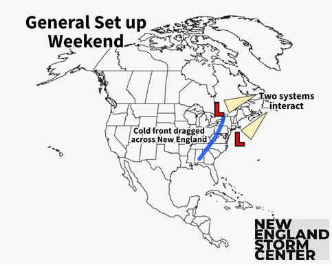
This weekend's wet weather is being set up by two systems. First, a rather weak area of low pressure will move offshore of the Carolinas and begin working up the coast. While this happens, a stronger area of low pressure will track across the northern tier of the country and move north of New England. This track will drag an associated cold front across our region. These two systems will interact and reinforce each other Saturday night.
Here's the general set up for this storm. You can see this set up on the weather model in the second image:
The bulk of the rain looks to fall Saturday evening through early Sunday morning. Showers will likely break out around midday Saturday as the initial area of low pressure off the coast arrives. Much of New England will begin drying out by sunrise Sunday, with isolated showers lingering in the morning hours. Maine will likely see showers continue through Sunday midday.
Rainfall amounts have continued to trend upward. This rain is needed for New England, particularly the parched southern New England. Southern Connecticut, Rhode Island, Cape Cod and eastern Maine have entered "abnormally dry" conditions on the US drought monitor. However, too much rain in too short of a time could lead to some issues.
Flood watches are currently not posted as of Saturday morning, however, if rainfall amounts continue to trend up in the next model run, flood watches will likely be posted, especially for southern New England. Whether or not these watches are posted later today will be something to keep an eye on.
Generally speaking, more rain will fall closer to the coast, with amounts tapering off as you get inland. Where the most intense rain bands will set up will be determined by exactly when the two systems interact with each other. Right now, it looks like the timing will result in the intense bands setting up in central Connecticut and Massachusetts. These areas could see upwards of three inches. Another area where three inches will be possible along Maine's midcoast. Much of New England will see 1-2 inches total.

With dew points running in the 60s during this storm, tropical-like downpours will be possible across eastern New England. Should these downpours set up in urban areas, some street ponding will be possible.
This storm is very progressive, so it will be moving along. This is the main factor limiting the flood threat, however, the flood threat is beginning to increase as rainfall trends up. After the storm, next week is looking to be generally cool and dry, although late next week has some big questions.
TIMING
Saturday morning: Scattered showers break out, Maine stays dry for now.
Saturday afternoon: Showers become more widespread, scattered showers break out in Maine.
Saturday evening: Heaviest bands of rain arrive.
Saturday night: Heaviest bands of rain arrive in Maine.
Sunday morning: Showers continue.
Sunday afternoon: Drying out begins.


Comments