Coastal Storm to Soak New England; Weekend Unsettled
- Tim Dennis
- Apr 27, 2023
- 3 min read
Updated: Apr 28, 2023
The one-two punch of storms coming to New England is still on track for this Saturday through Monday, although the timing of the systems has changed as the set up comes more into focus. Here's the latest on timing and impacts as confidence begins to increase.
SATURDAY
A warm front will lift across New England starting on Saturday morning. Showers will fire across the region (except Maine) by early afternoon. There will be widespread, but mostly light, showers throughout the day as the front squeezes out moisture. A couple rumbles of thunder will be possible as well.
Euro model showing rain shield approaching Saturday afternoon:

Showers will continue Saturday night as a frontal boundary associated with a cutoff low stalls over New England, keeping unsettled weather around. Widespread showers continue through the overnight hours. Maine will remain mostly dry on Saturday due to high pressure. Overall, Saturday has been trending less wet with lower total rain fall amounts.
SUNDAY
There will be widespread light showers lingering on Sunday morning as the frontal boundary remains stalled out. Much of New England will get a brief break from showers from mid morning through late afternoon. There will likely be isolated showers throughout the day, but it is not looking like a washout during this time frame. Western areas of New England will likely see more showers throughout Sunday.
Sunday night will see the arrival of the main event. An area of low pressure will emerge off the coast of the Carolinas and begin tracking northward over the ocean and collide with New England. The storm will strengthen quickly while over the ocean. The coastal storm will interact with the cutoff low, which is still hanging around the Great Lakes.
Coastal storm in full force early Monday morning:

This bulk of this storm's impact has continued to speed up, meaning much of New England will see the heaviest rainfall and gusty winds will strike overnight Sunday into early Monday morning. Very heavy and widespread downpours will be possible with this storm throughout the night.
MONDAY
Southern New England, Vermont and New Hampshire will see rain end from south to north starting early Monday morning through late morning. The storm will pull away very quickly, with mostly sunny skies possible in southern New England by the early afternoon! Vermont and New Hampshire could also see pops of sun by the afternoon. Being further north and east, much of Maine will see a steady rain throughout Monday as the storm progresses northeastward.
Southern and central New England cleared out by Monday afternoon:

Monday will see temperatures soar with afternoon highs hitting the upper 60s to low 70s across southern and central New England. Increased cloud cover will keep northern areas cooler, likely staying in the low to mid 50s.
RAIN TOTALS
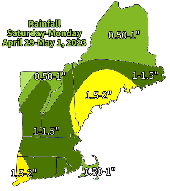
When all is set and done with both systems, a widespread one to two inches will fall across the region. Amounts have trended down slightly as the first system is not looking as potent as it did the last couple days. The highest rainfall is looking to be eastern New Hampshire into western and coastal Maine. Southwestern New England could also get into the highest amounts. The two systems combined could lead to minor flooding issues. Right now, some rivers could reach minor flood stage by Monday night or Tuesday.

WIND
Being a coastal storm, there will be some strong winds. Earlier this week, I wrote that the wind threat would be something to watch as the week progressed. It is still looking like winds will not be too much of an issue, with gusts up to 40-45 mph possible. Gusts at this level are below the threshold for damage, but an isolated issue is always possible with these coastal storms.
COASTAL FLOODING
Fortunately, coastal flooding is looking increasingly likely to be a non-issue. Winds coming from the south south east during the peak of the storm will help protect much of New England's most vulnerable coasts. On top of that, tides are astronomically low, so even the south coast and Maine coast should be fine.
BEYOND
That cutoff low will continue to hang around the Great Lakes throughout the coastal storm. After the coastal storm passes Monday night, the cutoff low will VERY slowly push eastward across New England. This will lead to a cool and showery week all week long. Next week is going very gloomy.


Comments