Speed Bump Incoming in New England's Tranquil Stretch of Weather
- Tim Dennis
- Sep 6, 2024
- 3 min read
For the next two days, New England will be sandwiched between two systems: a coastal storm to the east and a cold front to the west. The coastal storm will pass New England well offshore, sending only some clouds into eastern New England for the most part. The exception will be far eastern Maine, where the edge of the shield of rain may swipe Washington County. The cold front will push through New England Saturday late afternoon through Sunday morning, bringing a round of showers.

Friday will be the last completely dry day for the entirety of New England as these systems remain well to the east and west of the region. As the coastal storm passes through the outer Gulf of Maine, it will create rough seas with large waves and rip currents impacting the southern New England coast. A high surf advisory is in effect through Saturday evening for the Massachusetts coast. This will be the extent of impacts from this storm.
This storm is still being monitored by the National Hurricane Center as it may briefly become a subtropical storm. The NHC currently gives the storm a 20% chance of developing into a tropical or subtropical system. This doesn't change anything or heighten concerns, it's just an interesting development.
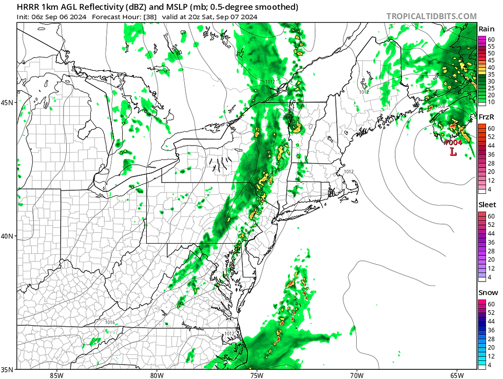
Heading into Saturday, most of New England will be dry for much of the day. The exception will be far western New England, where showers from the cold front may break out by mid afternoon and eastern Maine, where the outer bands of showers from the coastal storm may be able to swing into Washington County in the morning.
HRRR showing potential weather heading into mid-afternoon Saturday:

The shield of showers will slide eastward for Saturday evening and into Maine by early Sunday morning. Overall, timing of the end of showers has sped up, with most of New England outside of Maine seeing them just about end shortly after midnight. Maine will the showers last through sunrise being farther east. Showers will likely be more numerous across northern and western New England with the showers more scattered around and generally lighter across southern and central New England.
HRRR showing potential weather Saturday evening (1st image) and around midnight (2nd image):
When all is said and done, western and northern New England will likely have seen up to a half inch of rain. Lesser amounts will generally be seen farther east in New England as the line of rain weakens. Far eastern Maine may also see higher amounts depending on the exact track of the coastal system. More impactful rain totals of 1-3 inches will remain across Nova Scotia (from the coastal storm) and Quebec (from the cutoff low sending the cold front through New England).

The shield of rain from the cold front will have cleared New England by Sunday morning, but the region will remain under broad cyclonic flow, so a couple showers could spring up in the afternoon, mainly in the higher terrain. Overall, conditions will be drying heading into the afternoon on the flip side of the front. Temperatures will also be cooler on Sunday and brief humidity that began to build on Friday and Saturday will be erased.

One interesting development for Sunday is the fact that the freezing levels may drop to around 5,000 feet (or even lower across northern Vermont) in the Green and White Mountains. With the potential for lingering showers in the mountains on Sunday, some of the higher peaks could see some showers turn to a wintry mix or snow.
ICON showing projected freezing altitude on Sunday morning. This shows at what height above sea level (in feet) the temperature drops to 32°:

These weekend systems are looking more like a quick speed bump in our stretch of tranquil weather. After this weekend, another expansive area of high pressure is looking to set up for New England. While the overall setup for next week doesn't look as perfect as this past week, another very quiet, dry and comfortable week looks to be in store. A warm-up is looking more and more likely in the latter half of next week.


Comments