System Swirls Offshore of New England For Next Couple Days
- Tim Dennis
- Sep 19, 2024
- 3 min read
An area of low pressure has stalled out just offshore of Cape Cod this morning due to a blocking high to the north. As of Thursday morning, steadier batches of rain remain just offshore of Cape Cod. Just how much of this rain activity will end up making it over land in New England remains to be seen today. The highest rain chance continues to be the South Shore and Cape Cod with showers becoming less common moving north and west. Today will likely be a mainly dry day for most in New England.
Radar as of 8am:

This system will remain parked off the coast of Cape Cod through Saturday, wobbling around as it has nowhere to go. This will continue to cycle rounds of showers and clouds into eastern New England through Saturday. Again, how much of the steadier rain actually makes it over land won't really be known until it actually pushes to the coast. The storm does look like it will get shunted south and out to sea on Sunday, leading to a drying trend through the weekend.
WRF-ARW showing potential weather from Thursday morning through Friday evening:

Friday morning still looks like the time where the system makes its furthest push to the north. Western Massachusetts, southern Vermont and southern New Hampshire have the highest uncertainty with the frequency of showers as this area will be the battleground between the wet and dry air, although it looks increasingly likely that the drier air will win out in these areas.
The best chance for steadier rain and amounts of 1-2 inches will be across the South Shore and Cape Cod. Amounts will likely drop off more quickly heading inland, especially to the north. Northern New England will see very little to no rainfall from this system, but a backdoor cold front may bring a couple isolated showers to the north.

This system is reminiscent of a winter time snowstorm and trying to determine where the sharp northern cutoff in snow totals will be. The only real difference is with it being September, we're talking about a cutoff with (less impactful) rain instead of snow. This almost feels like the snowstorm (bust) from this past February when most of the snowfall missed just to the south.
Blocking patterns (and cutoff lows) come with the highest amount of uncertainty. This is why this has been a very changeable forecast. These patterns come with the highest uncertainty because storm systems can't move where they naturally want to since they're blocked in. When systems become cut off from the main flow, they're free to go pretty much wherever they want.
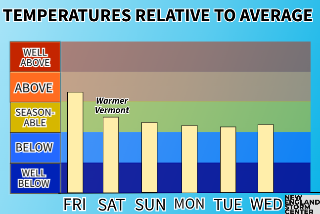
A renewed area of high pressure will build to the north of New England as this week ends. This will help shove the low away eventually and bring back drier weather once again. The position of this high to the north will allow for cooler and more seasonable temperatures to end this week and start next week with widespread 60s for high across New England starting this weekend. Overall, temperatures are looking very stable over the next several days.

After this low moves away from New England, the next chance for more precipitation in this bone dry month will come around midweek next week as a system traverses across the country. This remains just a chance as the blocking high will remain in place, which will try to delay or prevent this system from entering the region. This could lead to a weakening of the system before it arrives to the east. We'll be watching.
Weather map for next Wednesday (September 25):


Comments