Thunderstorm Chances Continue for New England; Watching the Tropics
- Tim Dennis
- Aug 3, 2024
- 3 min read
While this weekend will generally be unsettled, there will be many more dry hours than wet hours, especially on Saturday. Overall, Saturday has trended even drier for the daylight hours. A weak disturbance will pass through the region this morning. Once this passes through Maine, any morning shower chance will end and breaks in the clouds will develop.
Another disturbance will approach from the southwest this evening, but ridging between these two features should bring a mainly dry day. The afternoon will see the highest chance for a storm across the northern third of New England from an approaching frontal boundary.

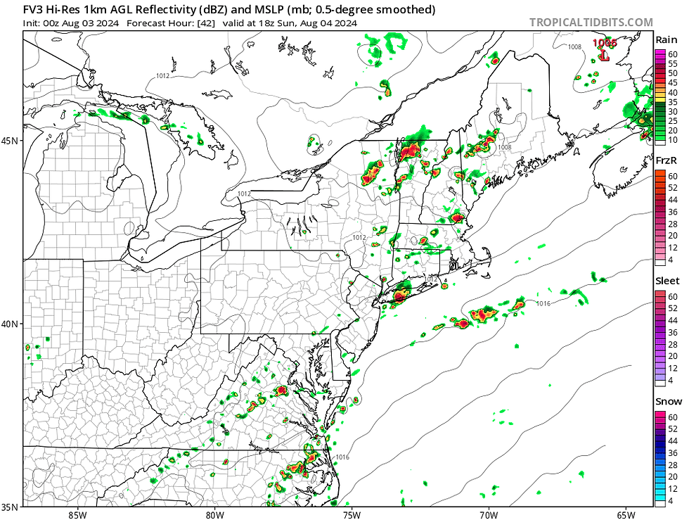
Connecticut and western Massachusetts will face the highest storm chances by mid-afternoon. The overall severe threat is low, but there remains a chance for a microburst, similar to what happened on Friday. Most areas saw sub-severe weather, but a wet microburst caused heavy damage in Granby and Simsbury, Connecticut. These storms will move northeast through night, weakening as they do so, similar to Friday night to Saturday morning.
HRRR showing potential weather from early afternoon Saturday through early morning Sunday:

Outside of the storm chances, the day will remain hot and very humid. Dew points across southern and central New England will likely exceed tropical levels. Some areas may approach the mid-70s for dew points. This, along with very warm air temperatures, will yield heat index values nearing 100°.

Storms will likely be more numerous around New England on Sunday as another disturbance moves through the region. After the morning round moves through northern New England, additional scattered storms will likely be around throughout the afternoon and evening. There will be a chance for some strong to severe storms with damaging winds being the primary threat, but severe storms likely won't be widespread.
With a moisture-rich atmosphere in place, storms will also be capable of producing torrential downpours. Rainfall rates could approach 2" an hour at times (it wouldn't rain at that rate for anywhere near an hour straight, however). Areas that see multiple storms in the afternoon could see some flooding issues develop, but this should remain a very localized threat.
GFS showing potential weather early Sunday afternoon:

Heading into next week, a cool-down is definitely in store (after Monday) as a cold front moves through the region and will likely stall to the south of New England. This boundary will also keep unsettled weather around. The other main story for the week will be the likely formation of Tropical Storm Debbie.
Debbie should officially be named later this weekend when the storm reaches tropical storm strength. There is high confidence that the storm will move through north Florida and then hug the east coast. After exiting Florida, the storm is now looking to slow down or stall near the southeast coast around mid to late week. There remains significant timing and track differences once the storm exits Florida, this is where confidence drops off significantly.

The question for New England will be how much tropical moisture will cycle around the storm up the east coast next week. Waves of rain could break off the main circulation and interact with the stalled frontal boundary over (or near) New England. Should this happen, it could produce bouts of heavy rain for portions of New England at some point. There's still a lot at play, and a lot that needs to be determined, so many possibilities remain in the picture, including just some lighter showers.
Current QPF forecast from the Weather Prediction Center through next week. Nothing about this is locked in, but the possibility of plenty of rain is there:

It's important to remember that New England could feel effects regardless of a direct impact from the storm. Should the storm stall out across the southeast, tropical moisture from the system's outer bands could interact with fronts near New England. Heading later into the week, the main system may continue up the east coast, but very large timing and track discrepancies remain (as you would expect at this range). With all this uncertainty, this is just something to keep in the back of the mind for now.
Ensemble tracks for the storm:


Comments