Up and Down Temperatures to Continue for New England as Dry Weather Prevails
- Tim Dennis
- Oct 24, 2024
- 3 min read
As of Thursday morning, a cold front has nearly finished crossing New England. As expected, the front only managed to squeeze out a few sprinkles here and there in the morning. Once this front moves offshore, a steadier northerly breeze will pick up, allowing cooler air to filter into the region.
Below: Surface map as of Thursday morning:

Temperatures for the rest of this week will be significantly cooler than the start of the week, however, it was so warm earlier this week that significantly cooler just means back to near average. The cooler air mass is lagging behind the frontal passage, so temperatures will not drop sharply either. Some areas of southern New England may be able to get to near 70° once again today. The cooler air really filters in for tonight with much cooler overnight lows.
Temperatures will remain stable through the rest of this week, but another cold front will push through the region during the day on Saturday. This front will usher in a cooler air mass than the one on Thursday, allowing temperatures to drop rather sharply for Sunday and Monday. Breezy conditions over the weekend will add to the chill in the air. Temperatures will be in the 40s north to low 50s south for Sunday and Monday.

After a break from chilly mornings, overnight lows will fall sharply behind this frontal passage as New England will be under high pressure once again. Just how cold the overnights get will depend on how calm winds get under the high. The coldest nights of the season are looking likely for New England Sunday and Monday nights. Overnight lows during this time will likely range from the low 20s north to low 30s south. The end dates for frost advisories and freeze warnings have passed for most of New England at this point, though.
Below: Temperature departure from average Monday morning:

Both the Thursday and Saturday cold fronts will be moisture-starved and have trouble generating widespread showers. The highest chance for showers with the Saturday front will be closest to the Canadian border. The greatest forcing for rain will come near the center of the low pressure system that the cold front is attached to, which is well to the north of New England. Very limited, if any, shower activity is expected south of the northern New England mountains.
Outside of these frontal passages, New England will continue to be dominated by expansive and rather strong areas of high pressure. This will continue for much of the next week, at least. Very little measurable rain continues to be depicted for New England over the next seven days. This comes as systems continue to be forced well to the north of New England.
Below: Weather Prediction 7-day rainfall forecast. Note the amount of forecast rain just to the north of New England. Unsettled weather continues to be directed well north around high pressure:

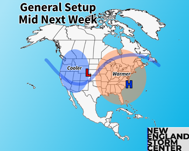
As for the temperature department, the cold air mass coming at the start of next week will not have staying power. A distinct trough-in-the-west-ridge-in-the-east pattern is looking to develop around the middle of next week. Signals continue to point toward a warm east coast and cool west coast for the time around Halloween.

This would allow for temperatures to climb right back to above average levels. This could usher in a brief return to the 70s for the time around Halloween for the warm spots of New England and 60s elsewhere. This is based on large-scale factors and exactly how mild it may get will depend on how smaller-scale factors set up (like potential frontal boundaries or onshore vs offshore flow). As of now, the Climate Prediction Center has New England with a 70-90% chance of above average temperatures for October 29-November 2.

Looking farther ahead, this warm-up may end up on the brief side. Other than the fact that we're getting late into the season for warmth to be sustained, a flip to a positive PNA is expected around the start of November. NAO is also expected to drop closer to neutral. All of this means that a pattern flip may come soon after Halloween, but we're really starting to get ahead of ourselves now.


Comments