Watching This Weekend's Storm Track Near New England
- Tim Dennis
- 2 days ago
- 4 min read
New England's most recent Alberta Clipper system is now moving away. This has dragged a rather strong cold front across the region overnight. A secondary front will be working through New England this morning. These fronts have triggered strong cold air advection, resulting in high wind gusts and continually cooling temperatures. High temperatures for the day have already been reached as temperatures will continue to fall through the daylight hours and into tonight. Temperatures will likely bottom out in the single digits north to teens south Friday morning.
Below: HRRR showing hourly temperatures from mid-morning Thursday through sunrise Friday:

The upper-level low remaining to the north of New England will aid in creating broad-cyclonic flow and an upslope snow shower event for the northern New England mountains on Thursday and potentially into Friday. This will help to tack on additional snow totals for the mountains and ski resorts. Upslope snow showers should gradually die down through the day Friday.
Elsewhere, the drier air mass should prevail, but broad cyclonic flow will still promote windy conditions with puffy cloud development in the afternoons. A wind advisory is in effect for most of southern New England (all but southern Connecticut). Winds will be gusting 35-50mph across the region, with highest gusts across southern New England.

All week long, the potential for a more organized and stronger coastal storm system has been watched for New England. While all storms tend to see flip-flopping between a direct hit and miss several days in advance among model runs, this one has truly been all over the place. The main source of uncertainty with this storm has been the level of interaction between the southern stream coastal storm and a northern stream system that will be passing north of New England.
More interaction (or phasing) between the two systems would pull the southern system closer to New England, as well as help the storm strengthen, bringing a widespread, accumulating snowfall. Little to no interaction would allow the coastal storm to remain weaker and drift out to sea well south of New England. Trends over the past 24 hours have been heading toward the second scenario with lesser impacts. With that said, guidance seems to be finally honing in on a potential "in-between" scenario, with a glancing blow rather than a direct hit or a complete miss.

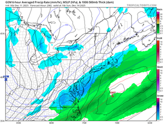
Most major models and ensembles now agree that the southern storm will pass outside the benchmark, but still close enough to bring a period of snow showers to southern and central New England. This could come with a period of widespread, steady light to moderate snow for areas south of the Mass Pike, particularly the South Shore and Rhode Island. Ocean temperatures may still promote more of a rain/snow mix across Cape Cod, but this will come down to the exact track.
Below: Current probability of impactful winter weather Sunday:

The general consensus for this glancing blow is that the storm will not be able to strengthen before it passes much of New England. This is due to not being able to take advantage of the stronger northern stream system in time. Outside of southernmost New England, a secondary area with a chance for steady snow will be Downeast Maine. This will come as the low manages to deepen across Nova Scotia. Like southern New England, a bulk of precipitation is currently expected to remain offshore of Downeast Maine, but the northern edge may clip the area.
Below: Model-roundup (Euro, GFS, CMC & AIFS) for Sunday afternoon. You can see some agreement is starting to be seen in some form of glancing blow. This agreement will need to continue through today's runs before more confidence in this outcome is raised:


This storm will not be a major storm for anyone, but light accumulations (perhaps a few inches) will be possible for southernmost areas and Downeast Maine. With that said, this storm and its track has been ticky-tack to say the least. It would not take much more interaction with the northern stream to yank the storm farther north, so higher impacts and more widespread snow across New England still can't be ruled out, as frustrating as that is. The main question will continue to be the northern extent of snowfall (something that is not so agreed upon on the above model runs).
After this storm passes, with whatever fanfare it brings, another blast of Arctic air is in store for Monday. This blast may be the closest one of the bunch seen over the past week. Wind chills will once again be dropping into the single digits for all, and sub-zero for northern areas. For those tired of this persistent cold, a major pattern change is in the works for the middle of next week.
The persistent and strong western ridge that has allowed for all this troughing and Arctic air to spill into New England will be breaking down. This will end the persistent ridge-in-the-west-trough-in-the-east pattern. The Pacific jet is expected to strengthen, leading to a more zonal flow. This will, in turn, allow milder Pacific air to spread eastward across the country.
