When Will Summer Heat Enter New England Again?
- Tim Dennis
- Jun 11, 2024
- 3 min read
Since the middle of last week, full-on summer heat (and humidity) has generally been elusive for New England. This has come thanks to the region being entrenched within a trough. An upper-level cutoff low has been sitting to the west or north of New England for nearly a week now.
This system is decaying as it very slowly pushes north and east, away from New England. This will bring New England a couple more days on the low end of seasonable with 70s dominating. Tuesday and Wednesday will be continuations of the past few days with scattered afternoon showers with more numerous activity in the higher elevations of northern New England. Wednesday could see some thunderstorms in the mountains.
GFS showing potential weather Wednesday afternoon:

After mid-week, we're watching two shots at summer heat. The first shot will enter into New England on Thursday and Friday with highs in the 80s for just about everyone. This will come as a deep southwest flow develops thanks to the position of high pressure to the south of New England and an approaching trough from the west.
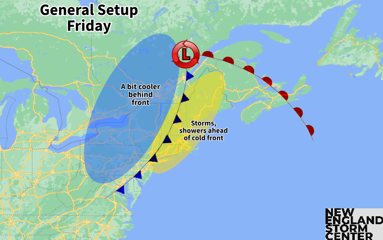
Despite this flow, humidity will remain in check with dew points generally in the 50s. Friday will see higher dew points into the 60s as New England gets into the warm sector of the approaching low, which will pass to the north on Friday.

This system will drag its cold front across New England at some point on Friday. This may bring New England a classic summer thunderstorm day. The timing and extent of storms will be determined by the timing of the passage of the cold front. There will be a chance for severe storms as the four main ingredients will be in place, though the extent of severe storms can't be predicted this far out. The day will be another warm one with higher humidity. The cold front will bring a quick end to this heat and humidity.

The front looks to clear the region by Saturday. This weekend will see a break in the heat and humidity thanks to the front. A large Canadian high pressure will build in from the northwest, promoting a dry northwest flow, temperatures mainly in the 70s, very low humidity levels and a mainly sunny sky. Not a bad weekend.
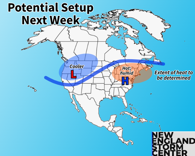
Next week is looking increasingly likely to feature above average temperatures and a return to heat and humidity. Signals have been pretty consistent showing a trough-in-the-west-ridge-in-the-east pattern developing. This will come with an expansive area of high pressure in the east, which may set up a heat dome. The position of this high will help determine the level of heat that will get into New England.

Since this is looking a week plus out, any sort of details on how hot and what the hottest days will be next week remain to be determined as small scale factors have to come into view. This sort of setup is supportive of the first heat wave of the season in portions of New England (the Connecticut River Valley, Merrimack Valley and Champlain Valley come to mind). Again, whether it gets hot enough for a heat wave or not is to be determined, but the possibility is there.

Humidity levels have generally been friendly for New England so far this season, generally staying on the lower end. Depending on how everything sets up next week, that could be over as well as high humidity will likely build with the heat.
Exactly how all of this sets up will also determine the level of any unsettled weather. Will it be hazy, hot, humid and dry, or will showers and thunderstorms be able to crop up at times? That question will be answered as we get closer to next week.


Comments