New England Weather This Week: Summer Here to Stay
- Tim Dennis
- Jun 30
- 4 min read

This week will feature weather you'd expect to kick off July in New England. Persistent warmth, varying humidity and rounds of thunderstorms will be moving through the region this week.
MONDAY
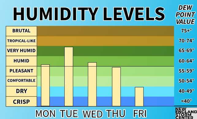
High pressure will dominate the region today. This high pressure system will move south and east of New England today, allowing for a southwest flow to develop, bringing warmer and more humid weather back to the region after the short hiatus late last week. Widespread 80s to low 90s are expected for highs this afternoon. The coast will be kept cooler thanks to the offshore high pressure allowing for a sea breeze.
Below: HRRR showing expected high temperatures this afternoon:

TUESDAY
On Tuesday, a frontal system will cross to the north of New England, which will first lift a warm front across the region in the morning before dragging a cold front through New England later in the day. This setup often results in an unsettled day with a couple rounds of thunderstorms and showers possible, and this system is no exception. The system's warm front will also usher in a very humid air mass, with dew points rising into the 70s for most of New England outside of Maine.

New England will likely see a round of scattered showers and thunderstorms in the morning associated with the warm frontal passage. Once the warm front passes, some clearing of the clouds will be likely, which will help destabilize the atmosphere for scattered thunderstorms to develop within the warm sector in the afternoon. These storms will likely form into a broken line as the cold front moves through later in the day.
Below: HRRR and WRF-ARW showing potential weather Tuesday morning (1st image) and around mid-afternoon Tuesday (2nd image):


It looks like the mid-afternoon through the evening hours will be the most active period of the day with thunderstorms likely scattered throughout the region. A pre-frontal trough may develop, which would help scattered storms form before the arrival of the cold front, which has trended toward crossing later in the day, toward the evening. With this fact, ingredients will be together to support some storms becoming strong to severe, with damaging straight-line winds as the main threat. Torrential downpours will also be possible.

Looking at the ingredients for severe storms, the warm frontal passage will set them up. Effective shear up 30 knots will be likely, moisture will be ample with dew points in the 70s, and lift will be provided by the cold front as well as the pre-frontal trough, which will help storms fire up through the afternoon rather than only along the cold front itself.
One issue will be instability, which may be hindered from building to its full potential by the round of morning showers and lingering cloud cover. Should clouds remain stubborn heading into the afternoon, not as much instability will build and storm activity will be more limited and muted later in the day. CAPE values won't be overly high either, but will likely be sufficient to support stronger storms.

While the ingredients will likely be in place, they aren't exactly jumping off the page, which is why New England is currently in the "marginal" category (level 1 of 5) for severe storm development. Depending on how trends go today with cloud cover and shear profiles, the threat could increase or decrease. Along with damaging winds, localized flash flooding will be possible with precipitable water values up to 2+". Small hail of brief tornadoes can't be ruled out should the trough form and discrete cells develop in the afternoon.
WEDNESDAY
The rest of the week will feature warm and less humid weather for New England. Broad troughing will dominate for the rest of the week, but a much drier air mass will preclude any widespread rain-makers and cooler weather. Wednesday will likely be pretty similar to Monday with widespread 80s and dew points in the low 60s.
THURSDAY
Thursday will likely see a sharper trough pass New England, with a surface cold front moving across the region later in the day. This may provide the basis for some pop-up showers and thunderstorms, especially later in the day. With that said, this system won't have much moisture to work with as Precipitable water values will likely be below an inch, so unsettled weather may have a tough time forming. In general, shower activity will be more likely the farther north in New England you go.

FRIDAY
After Thursday's cold frontal passage, temperatures will likely cool off slightly for Friday, but remain seasonable for early July. This cold front will bring humidity levels crashing down as well, with dew points in the upper 40s to low 50s. This will set up a rather nice Fourth of July for much of the region. With that said, a cold pool aloft will likely linger across the north, allowing for continued pop-up showers. These showers will likely remain contained to the north.
WEEKEND
Temperatures will likely gradually rebuild Saturday and Sunday, with each day a notch warmer than the last. Dry weather looks to be in store for Saturday with high pressure overhead ahead of a system that will be over the Great Lakes. Shower chances may begin to increase later on Sunday, especially for western New England, as a front approaches. Timing on any showers for later in the weekend remains uncertain, but overall, typical summer weather looks to hold strong.
Below: Current weather map for Saturday (July 5):


Comments