Wind Alerts in Effect as the Transition to Winter Continues
- Tim Dennis
- 3 minutes ago
- 5 min read
New England's next system will dive through New England later Wednesday into Thursday morning. Overall, Wednesday and Thursday's setup will be pretty similar to Monday and Tuesday. A big difference will be that it will be a notch cooler. Wednesday afternoon, a strengthening Alberta Clipper will dive into northern New England, bringing the next round of showers and wind. These will move west to east from the evening through the early morning hours.

Clouds from this system will begin to build into the region early this afternoon from west to east. Showers will likely break out across much of northern New England this evening, quickly moving west to east across Vermont, New Hampshire and Maine. Southern New England will likely see much more scattered shower activity later in the evening and overnight hours as the system's cold front pushes across the area. Areas in northernmost Vermont, New Hampshire and Maine may also see their first snow of the season Thursday morning as cold air crashes in and rain switches to mixing and snow showers.
Below: HRRR showing potential weather this evening (1st image) and around midnight (2nd image):


The biggest impact of this system will be the potential for strong to damaging wind gusts across a portion of the region. Gusts of at least 40mph will be seen by a vast majority of the region, but the southern half of New England could see some gusts closer to the 50 to 60mph range. High wind warnings have been issued for southern Vermont, western Massachusetts and Cape Cod. High wind watches remain in effect for most of the rest of southern New England and southern New Hampshire. These will either be upgraded or downgraded likely later this morning or early afternoon.

The reason why high wind watches were left in place rather than being changed this morning was due to the fact that overnight guidance has come in a bit less vigorous with the winds. Gusts of 50-60mph look to be the strongest gusts for a majority of southern and central New England. This is borderline between high wind warning and wind advisory (the threshold for a wind advisory to become a high wind warning is frequent gusts of at least 57mph). The Berkshires and Cape Cod stand the best chance at seeing 55-65mph gusts.
A strong low-level jet of 65 to 75mph will cross southern and central New England tonight as the Alberta clipper system quickly strengthens. Naturally, not all of this wind will make it to the surface. This jet will be strongest over the Berkshires and Cape Cod, where gusts will be the strongest. This will work in conjunction with a tight pressure gradient as high pressure tries to build in quickly behind the system. Atmospheric pressure may rise 6-8 millibars within a six hour window. This swift rise will create a very tight gradient, allowing for the winds aloft to make it to the surface easier.
Below: Winds at the 850mb level early Thursday morning, showing the low-level jet. You can see it will be strongest over the Berkshires and Cape Cod:

While the factors above point to an impactful wind event, there are factors working against winds reaching their full potential. With the system coming through at nighttime, it will make it more difficult for the winds aloft to mix to the surface. For full mixing, daytime heating is needed, and that (obviously) won't be present in the wee hours of the morning Thursday.
There is also a rather large spread in just how strong the low-level jet will actually become. Overnight trends have backed off on the strength of this jet as well as the overall strengthening of the Alberta Clipper. Should the clipper strengthen slower than anticipated, winds will not get as strong over New England. Winds will be lighter across northern New England, where the actual center of the system will pass.
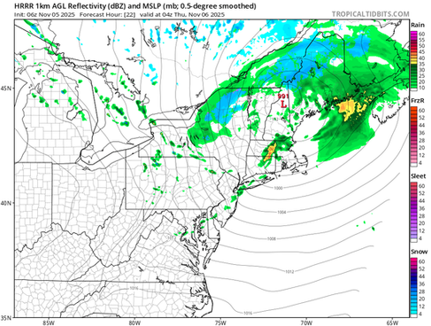
Below: HRRR showing the low's location moving right through New England early Thursday morning. Note that the central pressure drops sub-990mb in Maine:

Outside of the winds, Alberta Clippers tend to deposit the most amount of precipitation on their north sides. With the system moving through northern New England, it will be the northern tier of the region that sees the most, with a widespread quarter to half inch. Central and southern New England will likely see much lighter and spottier shower activity, with a tenth to quarter of an inch.
Areas in northernmost Vermont, New Hampshire and Maine may also see their first snow of the season Thursday morning. Snow levels will likely crash down to around 1,500 foot level (or lower into the mountain valleys) Thursday morning once the front crosses the region. Accumulating snow outside of the mountains is most likely across northernmost New Hampshire and northeast Maine. These areas stand to pick up a general 1-4 inches of snow. Winter Weather Advisories may be issued later today if trends move toward snow banding, bringing a period of moderate snow to these areas.
Below Current probability of at least 2 inches of snow by Thursday afternoon:

All of this comes as New England remains in a favorable location for storm development and strengthening. The pattern has been rather amplified, with general troughing over New England. New England has been sitting in the base of this trough, which is a prime area for storm strengthening. The pattern has also been very progressive, with low and high pressure systems quickly moving through the area in rapid succession. With rapidly strengthening storms quickly followed by high pressure, the pressure gradient remains tight, allowing for persistently high winds.
Below: Weather map from Monday, showing a sub-950mb storm near Nova Scotia with a 1,028mb high pressure to the west and New England caught in the middle. This is a prime recipe for high winds over New England. This will be repeated on Thursday:

This active pattern at the beginning of the month comes as the northern stream continues its annual migration southward for the winter, when it typically lays across the northern tier of the United States. In the warmer months, this stream migrates north, well into Canada. Systems will be moving through New England at a brisk pace through this weekend. With the base of a trough over New England and a brisk upper-level flow, the northeast becomes a hotbed for storm development. These storms have been strengthening just to New England's east, keeping impacts here more minimal and mainly limited to high winds.
Below: Jet stream map for the middle of this week, showing the northern stream laying across the eastern United States and right through New England:
