After a Rainy Day Today, Dry Weather and Warmth Return to New England
- Tim Dennis
- Sep 25
- 3 min read

After a round of scattered showers and downpours, mainly across southern New England this morning, a more widespread moderate rain with embedded downpours and thunderstorms will move across all of New England from southwest to northeast this afternoon and evening. This will come as a frontal system moving to the region’s west will lift its warm front across the region, providing a moisture-rich environment for continued rainfall.
Below: HRRR showing potential weather Thursday mid-afternoon (1st image) and Thursday evening (2nd image):


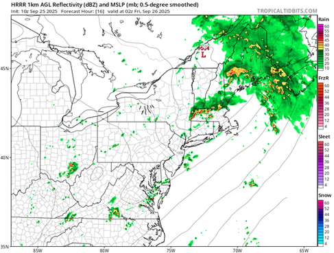
The main slug of rainfall will likely have pushed into Maine by tonight. This will steadily continue pushing northeast as the night goes on. The system’s cold front will be pulled through the region overnight tonight. This timing will make it more difficult to see scattered showers and storms along it, as they typically need the energy from daytime heating, but some scattered storms may have enough forcing and lift to be able to form overnight, as seen on the model run below across central New England.
Below: HRRR showing potential weather heading into Thursday night:

Precipitable water (PWAT) values are expected to climb well over an inch, possibly pushing to near two inches. PWAT is a measure of moisture in the atmosphere. PWAT values well over an inch indicate a moisture-rich environment that is primed to allow for a good soaking (should a mode of forcing exist, which, in this case, is coming from the frontal system).
A widespread 1-2 inches of rain remains likely across the region. This environment will allow for locally higher amounts as scattered downpours will be possible, especially within potential thunderstorms. Rainfall rates could briefly reach up to 2 inches an hour. This has already occurred in the Providence and southeast Massachusetts areas this morning, where flash flood warnings have been issued this morning.

This won't be a total drought-buster, but it will certainly help. It should be noted that the US drought monitor is updated weekly on Thursdays, but only factors in rainfall from the previous week through Tuesday morning (it basically measures rainfall and ground conditions from one Tuesday morning to the following Tuesday morning. The data is then analyzed and the map is updated by Thursday morning). So most of the rainfall this week won't be factored into tomorrow's update, but rather, it will be included in next week's update.
There is also a small chance for a few isolated strong to severe storms embedded within the rainfall. The main driver will be deep and effective shear with a low-level jet moving across the region. Naturally, this setup does not support a high amount of instability with thick clouds and multiple rounds of rainfall, and this will be the main limiting factor. The greatest chance for severe weather will be across the Mid-Atlantic today, which will be fully into the warm sector. The warm front will slowly be lifting through New England as the day goes on, but the region will likely have trouble getting fully into the warm sector.
Below: Surface analysis for this afternoon, showing the warm front across the northern New England-southern New England border:

The best chance for this to happen in New England by this afternoon and evening will be southwestern New England, mainly western Connecticut. With deep shear, there is a low tornado risk. Again, this will be highest south of New England, but it wouldn’t be shocking to see a severe thunderstorm or even tornado warning pop up across southwestern New England later today.
Below: Storm Prediction Center thunderstorm outlook for Thursday:

Heading into this weekend and early next week will likely see some sustained late-season warmth. A southwest flow under the return of ridging will likely allow for widespread 70s to low 80s across much of New England with plenty of sunshine. Saturday will likely be a notch cooler than Friday, Sunday and Monday as a secondary cold front zips through the region. Other than a few lingering showers Friday and a few showers along the cold front Saturday, New England will revert right back to the familiar mainly dry pattern.
Below: Temperature departure from average on Sunday:

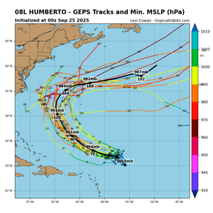
In the Tropics, Humberto has formed and will continue to strengthen. It is favored to reach major hurricane status (category 3+) by early next week. This storm is favored to remain offshore of the United States. It will likely be kept south of New England by the new ridging expected to set up over the region.
Another disturbance close to the southeast coast currently has a 90% chance of becoming the next tropical depression. This system has a lot of uncertainty with it as it will be close to Humberto. How the two interact will be a key driver in where exactly this system will end up going. Continued ridging over New England will likely keep this system south of New England as well.
Below: Spaghetti models for Humberto (1st image) and Invest 94 (2nd image):


Comments