Another Cool Weekend on tap with a Gradual Warm-Up Next Week for New England
- Tim Dennis
- Jun 12
- 2 min read

After a couple of warmer summery days, New England will be sliding back into familiar territory heading into the weekend with cool, cloudy and unsettled weather. This afternoon will be a touch cooler for northernmost New England as a cold front slides through the region with little fanfare. This front will likely be south of New England by Friday morning, bringing slightly cooler temperatures for everyone on Friday.
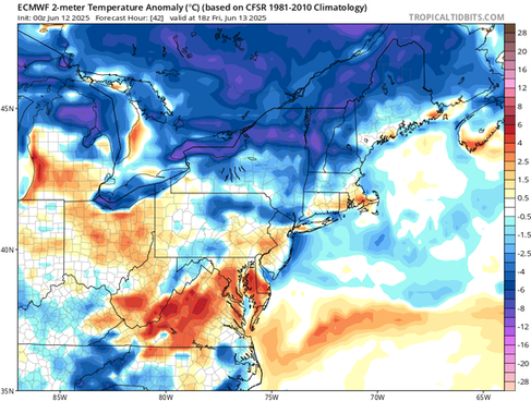
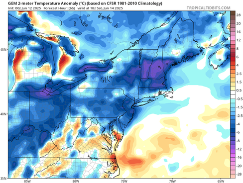
Below: Temperature departure from average this afternoon (1st image) and Friday afternoon (2nd image):


This frontal boundary will really be felt over the weekend as it stalls to the south of New England. A stalled frontal boundary over or near New England will almost always spell cloudy, damp and cool weather, and this weekend is no exception. A weak wave of low pressure will travel across the frontal zone set up between the boundary and an area of high pressure to the north of the region.

It's looking increasingly likely that Saturday will be more on the showery side rather than a very wet, washout-type day. The best forcing from the wave of low pressure looks to traverse the region Saturday morning, creating a wetter start to the day. A brisk flow off the ocean will continue throughout the day, setting up a typical onshore flow regime. This will keep clouds around with raw temperatures through the afternoon. Occasional drizzle or rain showers will also be likely. Conditions will be most raw and wet closer to the coast.
Sunday won't see too much of an improvement for most in the region. A continued onshore flow will keep the clouds, a few showers and cooler temperatures around, especially for southern New England and the entire coastal plain. The frontal boundary will still be to the south of the region with high pressure to the north. With this setup in place, the weather will be warmer and drier the farther north you go in the region as you get away from the influence of both the boundary and the ocean. With that said, it won't be particularly warm anywhere in the region, especially on Saturday.
Below: Temperature departure from average for Saturday afternoon (1st image) and Sunday afternoon (2nd image):


Moving into next week, confidence in the overall forecast does take a hit as zonal flow continues. This occurs when the jet stream lays flatter across the country, allowing systems to move through quickly. Timing out systems within a fast, zonal flow is a difficult task for current weather models. Weak, quick-moving systems could bring occasional bouts of showers or thunderstorms, but zonal flow doesn't support all-day soaking rain events. There's currently little precipitation in the forecast beyond this weekend.
For temperatures, a gradual warming trend is likely to commence after this weekend. Monday will likely remain cooler, similar to the weekend. The high pressure to the north of New England will eventually slide across New England early next week before moving offshore. This movement of the high pressure offshore will support warm air advection as it helps move mild air up the east coast. With that said, the offshore placement of the high pressure will likely lead to sea breezes, which could delay the arrival of warmer air for the coastal plain.


Comments