Cold Front to Bring Rounds of Storms, Rain Through Friday to New England
- Tim Dennis
- Jul 30
- 4 min read

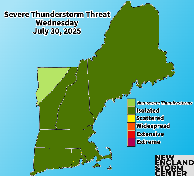
The ridge bringing this heat will begin to break down today, leading to a more zonal flow developing. A frontal system will approach and cross New England through the day today. This system will lift its warm front into the region, raising moisture content, before a cold front slides through later in the day. This will help set the stage for isolated to scattered thunderstorms this afternoon and evening.

Thunderstorm coverage today looks spotty at best with plenty of areas likely missing a storm. The greatest coverage of storms will likely be across the northern tier of New England, particularly Maine. Southernmost New England will be a secondary area to watch for more numerous storms late this afternoon and evening as well. Maine will see stronger forcing from the low pressure system while southernmost New England will see the highest instability build. In between these areas will likely see more isolated activity (or even none at all).
Below: FV3 showing potential weather later this afternoon:

The threat for strong to severe storms is on the lower end. The biggest limiting factors will be the fact that instability will be marginal at best and forcing will be weaker given the slow progress of the cold front. It also won't be quite as humid as it was yesterday, giving storms less to feed on. With that said, shear will be rather strong, which is the main factor working for severe weather. Overall, any severe weather looks to be rather disorganized at worst and non-existent at best.
Moving into Wednesday night and Thursday, the cold front will likely slow down further and stall either over southernmost New England or just south of New England, resulting in a period of unsettled weather through Friday, mainly for the southern half of the region. A wave of low pressure will likely ride along the stalled out front, bringing clouds and bouts of showers, storms and potentially downpours.

Timing on this bout of unsettled weather is starting to become more clear. Any storm activity today will likely begin to wane to weaken quickly after sunset. Showers will likely begin to ride the cold front through the day on Thursday, gradually increasing throughout the day. Showers will be most numerous across western New England and spread eastward.
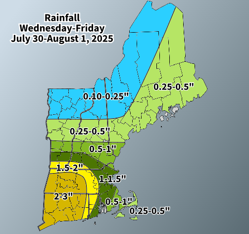
A period of more widespread rain is likely to develop by Thursday evening for the southern half of New England. Embedded within this rainfall will likely be scattered downpours. Rain will likely be at its most widespread and heaviest overnight Thursday into Friday. The system will push out of the region from northwest to southeast through Friday.
Below: HRRR showing potential weather late Thursday afternoon (1st image) and around midnight Thursday night (2nd image):


As has been the case through this week, guidance has continued to waffle back and forth on where exactly the axis of heaviest rain will set up. Yesterday, trends brought it farther north, overnight and this morning, this area has dropped back southward a bit. The waffling is thanks to the fact that the heaviest rain will fall along the frontal boundary, and exactly where that stalls is tricky to decipher.
The area where downpours are most likely to occur are apt to see upwards of 2-3 inches of rain through Friday. As of now the axis of heaviest rain is most likely to set up from the Mid-Atlantic through interior southern New England. There may be a rather sharp cutoff moving northward in New England, with the New Hampshire Lakes Region and points north currently looking at less than a half an inch. Flood watches may be issued for portions of southern New England. Alerts have not yet been posted (as of writing) due to the potential for further shifting of the highest amounts and uncertainty surrounding maximum rainfall.
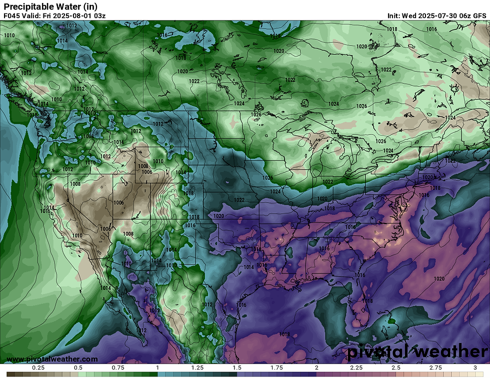
There are a couple factors lining up to bring this potential rainfall. Moisture will be highly elevated during this time, with precipitable water (PWAT) values approaching 1.5 to 2 inches. PWAT is a measure of water vapor contained in a column of air if it were to be condensed and collected. Basically, the higher the PWAT value, the higher rainfall rates could be, given a forcing mechanism for rain (low pressure system, frontal boundary, etc.) is present.
Below: Potential PWAT values Thursday night:
A sharp thermal gradient will also be in place, which could focus a band of heavier rainfall across a portion of southern New England. This banding is reminiscent of frontogenesis, which often sets up a band of heavier snowfall across the region during winter storms. Since we're still in July, we're talking about a band of heavier rain.
These factors will line up to bring scattered torrential downpours embedded within the rainfall. Areas that see multiple inches of rain could see localized and scattered flash flooding. Given the southern trends over the past 12 hours, the zone of flash flooding potential has also shifted south compared to yesterday evening's update.

This upcoming weekend is currently shaping up to be a great summer weekend. A large ridge of high pressure looks to build into New England. This is poised to bring dry conditions, seasonable temperatures and low humidity. There's currently not a whole to say about this upcoming weekend in the weather department, with a beautiful stretch of weather once the front clears.


Comments