Heat Persists Before Cold Front Brings Scattered Storms to New England
- Tim Dennis
- Aug 12
- 4 min read

The overall pattern will change very little today. The air mass will likely peak in temperatures, allowing for highs a couple degrees warmer. The air mass overhead is a rather dry one, so humidity will be kept in check. Dew points are expected to mix out into the low 60s during maximum afternoon heating, which is a far cry from the 70+° dew points seen in previous heat waves this summer. This will help keep feels-like temperatures close to the actual air temperature.
Below: Euro showing expected temperatures this afternoon:

On Wednesday, a cold front will begin to approach the region, and may cross into northwest areas. This will help bring northern Vermont back below the 90° threshold, though it still won't be cool. This front won't make much progress through New England on Wednesday, so much of the rest of New England will see another hot day. As per usual, more moisture will flow north ahead of the front, allowing humidity to tick up, so Wednesday may be more oppressive than Monday and Tuesday.

While the cold front likely won't pass through New England Wednesday, a pre-frontal trough will slide through ahead of the front. This trough, along with the increase in moisture, will help act as a mode of forcing for scattered showers and thunderstorms to develop in the afternoon and evening. Storms will be most numerous across the western half of New England (along with northern Maine), closer to the actual cold front, with more isolated activity moving farther east.

As the trough pushes through the region and the cold front slowly moves southward Wednesday night into Thursday, the chances for showers and storms will continue to push eastward. As per usual, the loss of daytime heating after sunset should allow precipitation to weaken, however, areas of showers will likely continue into the overnight hours Wednesday night.
How strong the cold front will be remains a question, and the strength will determine how much activity is seen during the overnight hours in regards to thunderstorms and general precipitation. If the front is weaker and forcing is minimal, little to no activity will be seen either Wednesday night or Thursday morning. A stronger front would allow for more activity. Either way, this should be scattered and plenty of areas across the region will likely remain dry during this time.
Below: Potential weather Wednesday night (1st image) and Thursday morning (2nd image). Note that there is still a wide range in potential coverage of precipitation Wednesday night among guidance:


For Thursday afternoon and evening, the cold front will continue its trek across the region. Cool air advection behind the front will be weak, so there won't be rapid relief from the heat or humidity. While temperatures will be knocked down a notch on Thursday, widespread 80s will dominate. Humidity will also remain elevated. With that in mind, the front will act more as a mode for lift and forcing for another round of scattered showers and storms.

Like Wednesday, shower and storm activity will be scattered in nature, so not everyone will get a storm Thursday. Despite the chances for multiple rounds of storms, there will also likely be plenty of dry hours and at least partial sunshine throughout the day as well. Overall, it will be a summery day with warmth, humidity and some storms around.
The threat for strong to severe storms will be on the lower end for both Wednesday and Thursday. There will be ample moisture and instability, but there are far more ingredients working against severe weather. These include weaker forcing and shear, mediocre lapse rates and drier air aloft.
The greatest chance for isolated stronger storms will be across western New England, where both instability and shear will be stronger. At this time, the deepest shear will be displaced from the higher instability, which lowers the threat level. Should CAPE values (a measure of instability) climb higher Wednesday, the severe threat could increase for western areas, which will be the main thing to watch. With ample moisture, brief bouts of (beneficial) heavy rain may develop on Wednesday across western areas.
Below: Current precipitation forecast for Wednesday to Thursday morning:

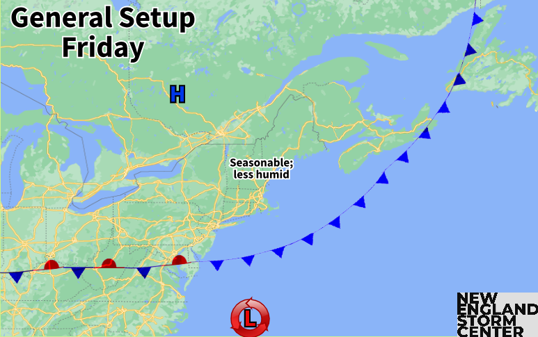
The cold front will likely have cleared New England by Friday morning. High pressure will build to New England's north, allowing for a drier and cooler air mass to take hold over New England. It won't really get cool behind this front, but a return to more seasonable temperatures is likely (mid 70s north to low 80s south).
TRACKING THE TROPICS
Tropical Storm Erin has formed in the open Atlantic Ocean. Erin will likely steadily strengthen as it moves westward. The storm is favored to become a hurricane by midweek and a major hurricane by later in the weekend. At this point, the most likely path for the storm long-term is a re-curve back out to sea before reaching the United States coastline, but trends will be monitored as the timing of the bend north remains a large question.


Comments