New England Remains Unsettled for the Rest of the Week
- Tim Dennis
- Sep 23
- 4 min read

The general weather setup for Tuesday and Wednesday will involve a slow-moving cold front gradually sinking southward through New England during the period. Multiple waves of low pressure look to ride along this boundary, bringing several rounds of showers and storms. Today, the cold front will generally be draped across northernmost New England as it continues its slow journey southward. This will keep the best chance for more numerous showers during the daytime across Vermont and northernmost New Hampshire.

Widespread showers will move across northern Vermont, New Hampshire and central Maine through much of the day. The cold front will continue to very slowly sink southward throughout the day, dropping the shower chances farther south in New England as the day goes on. By the afternoon and evening, scattered showers will likely be centered over central and southern New England. Some thunderstorms will be possible within the showers as well.
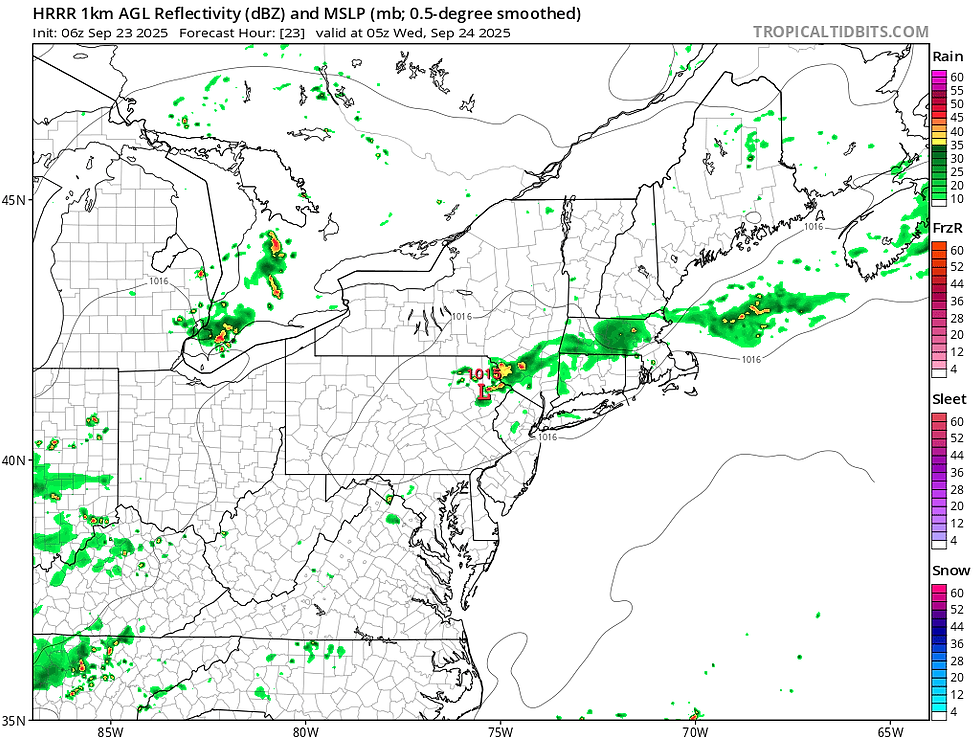
Below: HRRR showing potential weather early this afternoon (1st image) and this evening (2nd image):


The severe threat with any thunderstorm is very low, thanks mainly to marginal instability. CAPE values will likely peak at less than 1,000 units. There will be effective shear over 30mph, so an isolated stronger storm or two with gusty winds is certainly possible. Overnight tonight, the cold front will stall across southern New England. With a wave of low pressure riding along the front, showers will continue overnight, mainly across Massachusetts and southern New Hampshire.
Below: HRRR showing potential weather overnight tonight:
A southwesterly flow ahead of the cold front will bring a quick warm-up to much of New England today. Areas that end up seeing more constant showers this afternoon will naturally be a notch cooler, but central and southern New England are apt to reach into the low 80s today. It will also feel more humid as well, as a deeper moisture plume is pushed up the east coast.
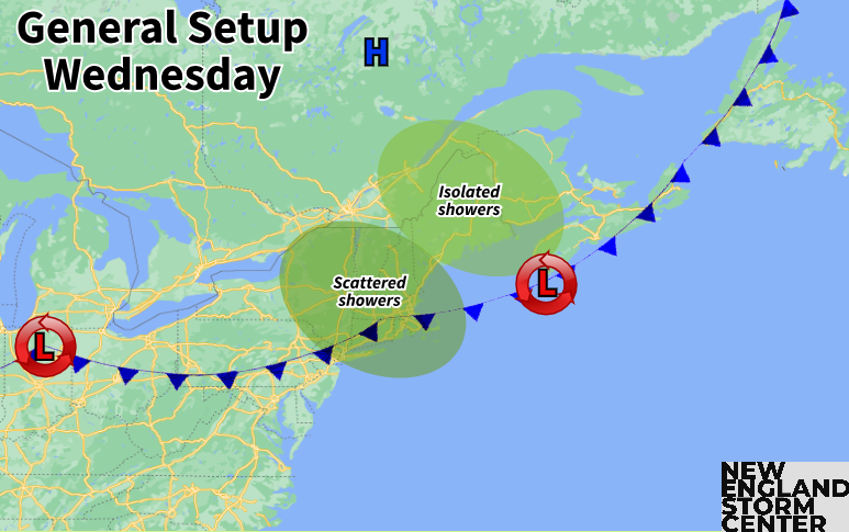
The cold front will remain virtually stalled across southern New England on Wednesday. This will likely keep unsettled weather around throughout the day with cloudy skies and scattered showers. The day won't be a washout anywhere, but multiple rounds of showers may pop up throughout the day with dry breaks in between. It will be much cooler than Tuesday as well on the other side of the boundary, but humid air will stick around. Overall, southwest New England looks to be the wettest and Maine looks to be the driest on Wednesday.
When all is said and done, a widespread quarter to half an inch of rain will likely have fallen across the region through Wednesday. The highest rain totals with this system are poised to set up across the southern half of New Hampshire into Massachusetts, where additional showers overnight tonight are most likely. This system has a better chance to bring widespread rainfall to New England than the past few systems as high pressure off the east coast will help pump deep Gulf moisture into the northeast. PWAT values will likely reach well over an inch during this time, indicating a moisture-rich atmosphere.
The trough centered over the Great Lakes will dig deeper into the central United States later in the week. This will allow another surface low pressure to form over the Midwest and push northeast, toward New England. This will be the main source of another potential round of rainfall. This system will likely lift to New England's west and north, acting as a frontal system for the region with a warm front moving in before a cold front.
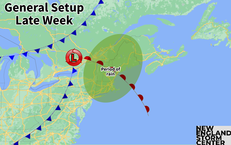
While there's still a spread on when the most widespread showers will come with this system, there is certainly washout potential for Thursday. At this point, the most widespread of the rain looks to move through Thursday afternoon into Thursday night. There could also be some embedded thunderstorms as well. Overall, Thursday may end up similar to Tuesday, but with far more widespread showers.
With the system moving to the west of New England, it will be interior New England that will have the best chance at the highest amounts. Overall, the plume of deep, Gulf moisture looks to continue to move up the east coast, allowing for moderate rainfall or scattered downpours. Again, this plume of moisture is what separates this system from the systems of the past few weeks that have dried up on arrival.
Below: GFS showing PWAT values Thursday evening:

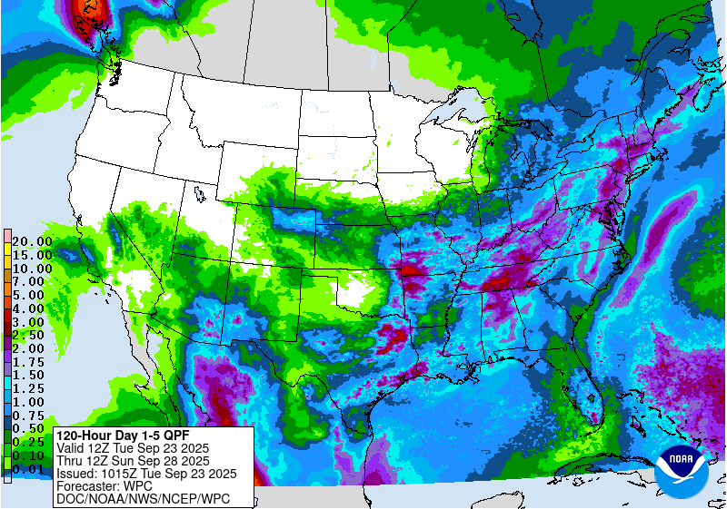
Between the Tuesday and Wednesday system and the Thursday to Friday system, New England could see a widespread 1-2 inches of rain. The highest amounts are Poised to set up right across central New England. Lesser amounts are more likely across northernmost and southernmost New England. This week won't be a drought-buster on its own, but it will certainly help.
Below: Current 5-day precipitation outlook:
There remains uncertainty on how exactly this weekend will play out, but recent trends over the last 24 hours have been toward a drier Saturday. A secondary cold front will likely approach New England this weekend. The southwest flow ahead of this front will likely bring another warm-up, with some isolated to scattered afternoon showers possible.


Comments