New England September Weather Outlook: Transitional
- Tim Dennis
- Sep 2
- 5 min read

The first month of meteorological fall has arrived and will see average high temperatures drop about 10° from the start of the month to the end. Officially, summer does not end until September 22nd, but in the meteorological world, the flip to a new season has arrived.
Summary: September will pick up right where August left off with little summer heat, little humidity and generally dry weather. With that said, the pattern is expected to slowly evolve and transition as the month progresses. When all is said and done, this may shape up to be a pretty average September. Generally dry weather is also favored to continue. Read below for the in-depth discussion.

TEMPERATURES
New England will be starting off September the same way August left off. That is to say high pressure will generally dominate at the surface while general troughing remains in place aloft. This is the general pattern that has been responsible for these long stretches of mostly quiet weather with little summer-like heat and almost no humidity. The first week of the month will see continued stable temperatures, with 70s dominating. The dry weather will briefly be interrupted with the passage of cold fronts at the end of the week.
The first half of September will generally feature a ridge-in-the-west-trough-in-the-east regime. This has been the general setup for a couple weeks and has brought New England's cooler August while the west coast has sizzled. A deep trough will develop later this week, centered over the Great Lakes region. This will bring very chilly temperatures to the Midwest and Great Lakes region through the end of the week. New England will be on the edge of this trough, so temperatures here will remain close to seasonable through this week.
Below: 500mb height anomaly late this week, showing the trough centered over the Great Lakes while ridging continues in the west:

The dynamics of this trough are interesting for September, as it involves a cross-polar flow. With a highly amplified ridge in the west and another ridge farther east extending toward the North Pole, the trough in between will see a corridor open up, allowing flow from across the Polar-region into the central United States. This setup brings the United States its most severe arctic blasts of each winter. With it being September, the effect is naturally muted, but it will be quite chilly given the time of year for the Midwest.
Below: 500mb height anomaly mean from September 3 to September 8, showing what is described in the above paragraph:

While New England will be on the edge of this trough through the end of this week, it will eventually send cold fronts through the northeast, which will once again cool things off after a brief and subtle warm-up (along with a spike in humidity) to close out this week as southerly flow develops ahead of the fronts. It won't be as chilly for New England next week as it will be over the Midwest this week, but generally cooler temperatures will persist after the fronts on Friday and Saturday.

As we make our way toward the middle of the month, signals continue to point toward a broad shift in the overall pattern. While a ridge-in-the-west-trough-in-the-east pattern has generally dominated over the past few weeks, this does show signs of breaking down as the month progresses. A more zonal flow (when the jet stream lays flatter across the country as opposed to deep ridges and troughs) is expected to take shape. A weak trough is expected to develop across the west coast eventually.
This transition will bring milder conditions back to the Midwest while New England likely remains closer to seasonable levels. The Climate Prediction Center's 8-14 day outlook captures this transition well. Cooler temperatures are slightly favored to hold on in the northeast due to the departing trough early in the period. The west cools down as a trough develops toward the end of the period while the central US becomes milder. It should be noted that this transitional pattern comes with inherent uncertainty due to how exactly it evolves and the speed at which the evolution occurs. The 8-14 day outlook is currently rated a 2 out of 5 on confidence, which is below average.

Heading toward the second half of the month, there are mixed signals on how exactly the pattern will evolve. An enhanced ridge is expected to develop across Canada, more specifically near Hudson Bay, and extending eastward into the Atlantic Ocean. This would be consistent with the general transition expected to occur through the middle of the month. The main question will be the southward extent of above average heights. These above average heights are most likely to expand southward into the United States across the Plains states.
Exactly where and how this ridge sets up will likely determine whether New England sees a generally milder end to the month, or if the cooler temperatures will end up ruling much of the month. Regardless of the ridge's general location, cold fronts will continue, bringing cooler bouts throughout the month. Overall, we're predicting a near-average month temperature-wise, with multiple ups and downs through the month. Should the cooler solution take hold for the second half, the month will likely skew below average as a whole, however.
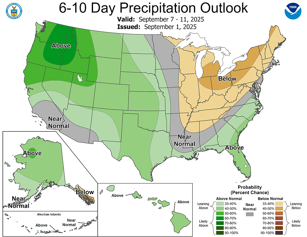
PRECIPITATION
The precipitation outlook for September looks like a general continuation of August's generally dry weather. With surface high pressure continuing to dominate across the northeast, New England will likely continue to see longer stretches of dry weather punctuated by brief wet periods. This week will be bone dry for most with the cold fronts late this week bringing wetter weather on Friday and Saturday. After that, high pressure takes hold once again thereafter, with another stretch of dry weather for next week.
This general pattern does look to continue for much of this month. With that said, we're predicting a below-average month for precipitation. One of the big uncertainties in September for rainfall comes with the fact that hurricane season reaches its peak activity. Whether New England sees a direct impact from a tropical cyclone or the remnants of one moving through, it could quickly turn what was looking like a below average month into an above average one.
LOOKING BACK
We predicted a generally above average August for temperatures, but also noted that the ups and downs seen throughout this summer would likely continue. The ups and downs did continue, but the downs ended up being stronger than the ups, which led to a below-average month overall. New England's cities generally ranged from 0.5 to 2 degrees below average as a whole. The persistent cool weather at the end of the month, as well as the cooler start overpowered a warmer middle. We also predicted below average precipitation, which did pan out.
Below: Daily temperature chart for Boston for August 2025:


Comments