New England Weather This Week: Hot
- Tim Dennis
- Aug 11
- 3 min read

A return to full summer heat is on tap for New England this week, with persistently high temperatures and moderate relief toward the week's end. It will be another generally dry week, but scattered storms are possible for some around midweek.
MONDAY & TUESDAY
The heat wave that began yesterday (and for some, on Saturday) will peak through the first half of this week. Widespread 90s across much of the region expected for Monday through Wednesday. Tuesday looks to be the peak of the heat as temperatures aloft will reach their climax. Temperatures at the low levels (2,500 to 5,000 feet above sea level) will likely push into the upper 60s to 70s, supporting widespread 90s at the surface across much of New England.
Below: Euro showing potential temperatures Tuesday afternoon:

The overall pattern will change very little from Monday to Tuesday, with each day very similar to the other. The air mass overhead is a rather dry one, so humidity will be kept in check. Dew points are expected to mix out into the low 60s during maximum afternoon heating, which is a far cry from the 70+° dew points seen in previous heat waves this summer. This will help keep feels-like temperatures close to the actual air temperature.

One thing to watch will be for the potential of low-level onshore flow as the surface high pressure will be just to New England's south and east. This onshore flow would be weak given the overall setup and the fact that it's now August, however, it could be just enough to keep the coastal plain a smidge cooler. If the offshore flow is strong enough, this will not occur, but it will be something to watch. Even with these factors, it will still be well into the 80s and 90s, so these factors won't prevent the heat wave, but rather take the edge off, a bit.
WEDNESDAY & THURSDAY
On Wednesday, a cold front will begin to approach the region, and may cross into northwest areas. This will help bring northern Vermont back below the 90° threshold, though it still won't be cool. This front will likely slow down and stall, or maybe even retrograde back westward as it weakens, so much of the rest of New England will see another hot day. As per usual, more moisture will flow north ahead of the front, allowing humidity to tick up, so Wednesday may be more oppressive than Monday and Tuesday.
The cold front will continue its eastward trek on Thursday, knocking down temperatures for the rest of the region through the end of the week. Highs on Thursday will remain quite toasty for most, but will be a notch cooler than Monday-Wednesday. Humidity will remain elevated as well as it will take time for the more refreshing air to reach the surface behind the cold front.
Below: Euro showing expected temperatures Wednesday afternoon (1st image) and Thursday afternoon (2nd image):


The added moisture Wednesday and Thursday will help increase the chances for scattered storms to bubble up each afternoon. The increased moisture will also be accompanied by higher instability, promoting the chance for some storms. With that said, forcing from the front looks mediocre and clouds ahead of the storms may lower instability as well. This means storm activity may end up spotty to scattered rather than widespread, but the exact extent of storms each day will come into better focus with high-resolution guidance in the coming days.

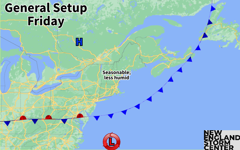
FRIDAY
The cold front will likely have cleared New England by Friday morning. High pressure will build to New England's north, allowing for a drier and cooler air mass to take hold over New England. It won't really get cool behind this front, but a return to more seasonable temperatures is likely (mid 70s north to low 80s south).
WEEKEND
The early report on this upcoming weekend looks a lot like this past weekend. The upper-level ridge will be suppressed Friday and Saturday, but it will likely try to quickly rebuild as the weekend goes on. This would create a warming trend, with Saturday a notch warmer than Friday and Sunday back into full heat.
This is currently the favored outcome for a majority of New England, but another cold front will likely be approaching late in the weekend. This front could cool off the northern tier as well as promote scattered showers and storms later Sunday. The timing of this front will be watched through the week.
Below: Current weather map for Sunday morning (August 17):


Comments