New England Weather This Week: Humid
- Tim Dennis
- Jul 14
- 4 min read

This week will feature persistently high humidity and increasing temperatures through midweek. A cold front will bring rounds of scattered storms late in the week along with lowering humidity and temperatures.
MONDAY
On Monday, the cold front will slowly push through New England, bringing a better chance at more widespread shower and storm activity across New England. This front will provide stronger lift for storms versus the past couple days, but the front will be weakening as it pushes eastward. The overall trends have slowed the cold front down more, likely not moving across New England until overnight Monday night.

The threat for the heaviest downpours and potential localized flooding will occur just ahead of where the front will be in the afternoon. Given the orientation of the front, this would put much of western New England in the zone with the highest storm and downpour activity. The overall threat of the highest rainfall has continued to trend southward, with the center of activity now expected over the Mid-Atlantic rather than New England. A flood watch is in effect for western Massachusetts and Connecticut.
Below: Excessive rainfall outlook for Monday:

With a slow-moving front and weak wind fields, storms will likely once again be slow-moving. Moisture will pool ahead of the front, setting the stage for the potential for heavy rainfall rates. Precipitable water values (a measure of water vapor in the atmosphere that could become precipitation) will remain highly elevated. Rainfall rates of 1-2 inches an hour will again be possible within storms.
The current threshold for flash flooding to occur across much of New England is 1.5-2.5 inches in an hour. The threshold for flash flooding within three hours is generally 2-3 inches. There will be the potential for training thunderstorms (when one storm moves over multiple areas) close to the frontal boundary given flow is parallel to the front. One area that will need to be watched is the Northeast Kingdom as the flash flood threshold is currently below 2 inches within 3 hours given the recent flooding. With that said, the highest rainfall and threat of flash flooding has been trending south, away from this area.

Any flooding issues at this time will likely remain isolated and localized in nature. It will likely be similar to what has been occurring over the past few days, with localized flash flooding warnings issued as small storms bubble up, affecting a small area. Weak shear and marginal instability will keep the risk of severe storms isolated, with high winds being the biggest threat. Wet microbursts are certainly possible, which would result in localized damaging winds along with a flooding theater.
TUESDAY & WEDNESDAY
A transition back to hotter temperatures will begin in earnest on Tuesday with surface high pressure and weak mid-level ridging in control. This will bring sunnier weather (though full sunshine without any clouds is unlikely) along with an increased southwesterly flow. Widespread highs in the mid-80s north to low-90s south are likely for Tuesday with temperatures ticking up a notch on Wednesday as ridging will peak, with widespread 90s likely region-wide. Tuesday will likely begin a heat wave for interior New England.
Below: AIFS showing potential temperatures Wednesday afternoon:

Along with the heat will bring continued humidity. While the weekend wasn't overly hot for most, it was very humid. This will continue through much of this week, with air temperatures getting hotter as well. Widespread dew points in the 70s midweek will bring feels-like temperatures well into the 90s to around 100° for typical warm spots (mainly the Merrimack, Connecticut River and Champlain Valleys).

While this period will be mainly dry with at least partial sunshine, the overall atmospheric conditions may support isolated storm activity each day. Forcing will be weak and mid-level ridging will do its best to keep everyone dry, but a moisture-rich atmosphere, hot temperatures and marginal instability may allow for a few storms to pop up here and there in the afternoons.
THURSDAY & FRIDAY
On Thursday, a frontal system will likely begin to approach New England. This will allow for more widespread storm and shower activity across New England. With that said, this activity does not appear to be widespread enough to prevent temperatures from reaching well into the 80s and low 90s once again, so temperatures have trended up for Thursday. With an increased southerly flow, dew points will continue to climb with widespread 70s likely. Dew points well into the 70s will be possible in some places, leading to a tropical feel.
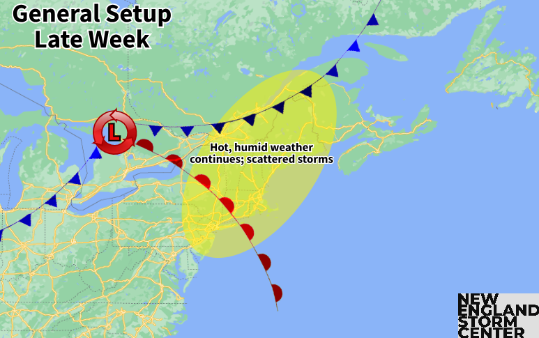
Prefrontal energy will likely allow for scattered storm development in the afternoon on Thursday. The system's cold front will likely drive through New England sometime Thursday night through Friday night. This may set the stage for another round of scattered storms on Friday, though this remains a question as it will come down to the timing of the front. Flash flooding and strong storms will be possible each day, but the exact threat level (whether it's isolated or more widespread) remains uncertain as that will come down to exact timing.
Friday will likely begin a cooling trend for New England as the cold front slowly slides through the region. Friday, however, will have the potential to be another hot day for southern and central New England as the front likely won't pass through until later in the day. The northern tier will likely get relief starting on Friday.
Below: Euro showing potential temperatures Friday afternoon. Should the cold front trend faster, the hotter temperatures would be suppressed farther south than what's currently being shown:

WEEKEND
Behind the cold front will be much lower dew points and seasonable temperatures. Overall Saturday currently looks very quiet and pleasant with high pressure in control and a refreshed air mass. Another frontal system may approach early next week and, depending on the timing, could see some showers or storms develop later in the day.
Below: Current weather map for Saturday (July 19):


Comments