New England Weather This Week: Wetter
- Tim Dennis
- Sep 22
- 4 min read

This week will be in stark contrast to the last few, with plenty of clouds and multiple rounds of showers. There are even a couple chances at a more widespread rainfall as well.
MONDAY
Today will act as a transition day from being dominated by high pressure to being dominated by low pressure for New England. The high pressure system that sat directly over New England this past weekend will shift east, over the Gulf of Maine. A stretched out trough will be moving eastward and will set up across the Great Lakes into the northeast. The high pressure will generally hold today, bringing one more dry, tranquil day. The return flow around the incoming trough and high pressure will bring a warm-up compared to this weekend.

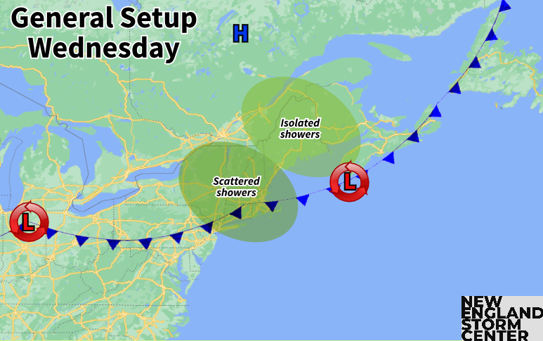
TUESDAY & WEDNESDAY
The general weather setup for Tuesday and Wednesday will involve a slow-moving cold front gradually sinking southward through New England during the period. Multiple waves of low pressure look to ride along this boundary, bringing several rounds of showers and storms. There certainly won't be a continuous rain during this time, as breaks between the low pressure systems will bring periods of dry weather as well.
On Tuesday, the cold front will generally be draped across northernmost New England as it continues its slow journey southward. This will keep the best chance for more numerous showers during the daytime across Vermont and northernmost New Hampshire. Central and southern New England will see a warm day with a southwesterly flow ahead of the boundary. Highs well into the 70s to low 80s, along with increasing moisture, will likely allow for isolated to scattered thunderstorms and showers in the afternoon.

A slug of widespread, steadier rain will likely come to central and southern New England Tuesday evening through Wednesday morning. This will come as the cold front sags southward and a more organized area of low pressure rides along the boundary. The scattered activity in the afternoon will likely increase in coverage through the evening and into the night until a widespread rain has developed. The area that sees the most from this slug of rain will be the area where the cold front is located Tuesday night. While this can change, it looks to set up across central and southern New Hampshire into Massachusetts.
Below: Euro showing potential weather Tuesday night:

A widespread quarter to half inch of rain is possible from Tuesday through Wednesday, with the highest amounts possibly pushing a half inch to inch of rainfall. Again, the highest rain totals with this system are poised to set up across the southern half of New Hampshire into Massachusetts. This system has a better chance to bring widespread rainfall to New England than the past few systems as high pressure off the east coast will help pump deep Gulf moisture into the northeast. PWAT values will likely reach well over an inch during this time, indicating a moisture-rich atmosphere.
Below: Current rainfall projection through Wednesday morning:

The cold front will likely continue its march through southern New England throughout the daytime Wednesday. This will likely keep unsettled weather around throughout the day with cloudy skies and scattered showers. The day won't be a washout anywhere, but multiple rounds of showers may pop up throughout the day with dry breaks in between. It will be much cooler than Tuesday as well. Overall, southwest New England looks to be the wettest and Maine looks to be the driest on Wednesday.
THURSDAY & FRIDAY
The trough centered over the Great Lakes will dig deeper into the central United States later in the week. This will allow another surface low pressure to form over the Midwest and push northeast, toward New England. This will be the main source of another potential round of rainfall. This system will likely lift to New England's west and north, acting as a frontal system for the region with a warm front moving in before a cold front.
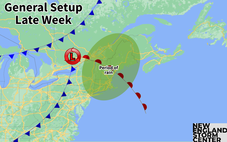
Current timing shows Thursday may be similar to Tuesday, with scattered showers, gradually increasing in coverage from west to east as the day goes on. The most widespread would come later Thursday into Friday morning. With that said, timing is nowhere near locked in with this, and it will likely change at least somewhat. The bottom line is that generally unsettled weather the multiple rounds of rain will likely continue through the end of the week as well.
While timing can change, it will very likely bring more rounds of rainfall to New England. With the system moving to the west of New England, it will be western New England that will have the best chance at the highest amounts. Overall, the plume of deep, Gulf moisture looks to continue to move up the east coast, allowing for moderate rainfall or scattered downpours. Again, this plume of moisture is what separates this system from the systems of the past few weeks that have dried up on arrival.
Below: GFS showing PWAT values Thursday evening:

While the signal is there for a bout of steadier rainfall, there remains a decent spread on amounts, and where the heaviest amounts may set up. With that said, some areas could end up much drier than others across New England. It will all come down to the position of the system to New England's west. Trends will be watched throughout the week, as a trend toward a drier solution does remain possible.
WEEKEND
A secondary cold front could move into New England early in the weekend, allowing the shower chances to spill into the weekend. This front may wash out over the region, bringing drier weather for Sunday. Overall, the weekend is very uncertain at this time, especially given the uncertainty with the late week system.
Below: Current weather map for Saturday morning:


Comments