Nice Saturday will be Followed by Unsettled Sunday for New England
- Tim Dennis
- Jul 26
- 3 min read
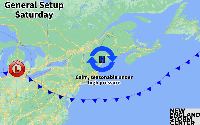
Yesterday's cold front slid to the south of New England this morning. While it has slowed down, it has pushed far enough south to allow for a very nice mid-summer day. High pressure will build right over New England this afternoon, bringing a drier air mass with seasonable temperatures and lower humidity.

The biggest weather story for New England today has become a plume of distant wildfire smoke that moved into the region overnight. This dropped the air quality into the unhealthy category for a large swath of northern New England this morning. Air quality is expected to gradually improve through the day, but it's expected to mix out slowly given the light winds and stagnant air under the high pressure system. An air quality alert is in effect for all of Vermont as well as eastern and coastal Maine.
Below: Air Quality Index as of Saturday morning:

A full departure of this smoky air will likely occur tonight as winds turn more southerly this evening and overnight. A system will ride the front and begin to pull it back north on Sunday, bringing unsettled weather back into the picture with showers and possibly some thunderstorms. While there's still a spread on where the most numerous showers will set up, it appears to be focusing on the southern half of New England.

The precipitation may come in two main batches throughout the day. The main batch appears poised to move into western New England early in the morning and steadily push eastward through the morning hours. A spread does remain in exactly where the bulk of this batch of rain will set up, but it looks most likely to produce the most numerous showers over central New England (northern Massachusetts, southern New Hampshire, southern Vermont). Some guidance does push it farther north, however.
The main reason for this spread in the bulk of rainfall is the position of ingredients for the rainfall. The higher moisture content will be across southern New England with drier air aloft moving farther north, but the strongest forcing will likely be across northern New England as the parent low pressure system moves north of the region. This is why central New England may land in the 'sweet spot'.
Below: Two different mesoscale model runs for Sunday morning. You can see one favors a more northerly push while the other keeps it more south:
This overall setup is reminiscent of a winter storm and trying to determine where the main band of snow would set up. This is because there is an abundance of dry air aloft to the north, so the question becomes how much can the atmosphere saturate across northern New England to allow for showers as opposed to staying dry. Since we're in July, this question will focus on rainfall amounts rather than snowfall. In the afternoon, instability will build, which may allow for continued scattered showers and a few thunderstorms to develop through the afternoon.
Below: HRRR showing potential weather mid-morning Sunday (1st image) and mid-afternoon Sunday (2nd image):
While the atmosphere isn't overly primed for torrential downpours, periods of heavier rainfall will be possible, especially if thunderstorms can develop. This means total rainfall will likely end up highly varied across New England. Some areas may struggle to reach a tenth of an inch while others will likely push over one inch. Maine will likely end up on the drier side of that range while western New England (mainly southern Vermont and western Massachusetts) looks to end up on the wetter side.
Below: Current precipitation forecast for Sunday:

With all of that said, it's unlikely to be a full-on all-day washout as breaks within the showers remain likely. Some areas could end up seeing more wet hours than dry hours, however. After this weekend, the heat will likely ramp back up along with high humidity. By Thursday, a cold front looks likely to drop through New England, potentially bringing a rather sharp cool-down. The theme of this summer has been high heat followed by quick relief, and that looks to continue over the next week, at least.


Comments