Snowstorm Incoming to New England on Tuesday
- Tim Dennis
- 2 minutes ago
- 3 min read
A deepening low pressure will likely be pulling out of the Mid-Atlantic and pushing northeast toward New England early next week. The overall setup and position of this system will favor cyclogenesis, especially with the colder air setting up over land and a still relatively warm ocean here at the beginning of the season. Guidance is becoming to hone in on a track near, or just inside the benchmark.

The general timing of this system has sped up a bit over the past 24 hours. A bulk of the system now looks to occur Tuesday afternoon and evening before winding down throughout Tuesday night. The storm will likely steadily spread from southwest to northeast through the morning hours. With no downstream blocking in place, this will be a rather short-duration storm. The storm still looks to completely clear out of New England by sunrise Wednesday.
As stated before, guidance seems to be honing in on a track near the benchmark. This is represented by loose clustering of ensembles near this point for Tuesday evening, which has held steady now for the last 24 hours. This track would result in steady snowfall being the dominant precipitation type for a majority of northern New England as well as interior southern New England. This would place the storm's jackpot zone across central New England (southern ME, NH, VT; northern and western MA). How much could potentially fall in this jackpot zone remains to be determined.
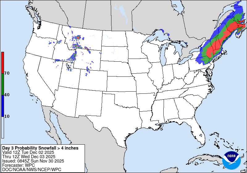
Below: Current probability of at least 4 inches of snow:

While there will be cold air moving into New England before this system arrives thanks to today's system bringing a cold across the region later tonight and Monday, there won't be a strong area of high pressure north of New England to lock it in place. This means precipitation type near the coastal plain will be completely determined by the track as the track will have a massive influence on temperatures. Confidence in a plowable snow has increased for the Berkshires, Litchfield Hills, northern Worcester Hills, southern Green Mountains, interior southern New Hampshire and interior Maine.
Those areas listed above are increasingly likely to end up in this system's jackpot zone. Confidence has actually decreased over the past 24 hours in regards to a rain/snow line closer to the coast. This morning, the National Blend of Models range at the 50th percentile has increased for these areas. Some areas have around a one foot difference in snowfall from the low end potential to the high end potential.
Below: Probability of minor and moderate winter weather impacts:

There will be no downstream blocking ahead of this system, so a quick exit is likely Wednesday morning. This will help to keep snowfall amounts in check as well, as this may be a 12 hour storm with rapid clearing at the end. This may end up being a classic 4-8 inch jackpot zone snowfall. The biggest question for snowfall will be how close to the coast this 4-8 inch area can get. It will likely set up across interior southern and central New England. How expansive will it end up being?
Below: Current probability of at least 4 inches of snow (1st image) and at least 8 inches of snow (2nd image):
Exactly where the storm tracks and how strong it gets will play a major role in overall snowfall amounts. These two factors really go hand in hand, as the stronger the storm gets, the more amplified it will get and the closer it track to New England, On the other hand, if the storm doesn't strengthen enough, it will take a flatter, less amplified path across the northeast and pass outside the benchmark. The second scenario represents the biggest way this storm could bust.
Should the storm track directly over Cape Cod, it would push the rain/snow line farther inland across southern New England, with heavy snowfall occurring across the southern half of northern New England. Should it track closer to the benchmark, or outside of it, most of New England would see snow with the rain/snow line confined to the coast, but it would likely be a bit lighter in nature. As of now, a track closer to land is more likely than well out to sea. This is represented by the fact that there is up to a 30% chance for at least a foot of snow across central New Hampshire, as seen below.
Below: Current probability of at least a foot of snow:


Comments