System Brings Rain (for some) Today Before New England Warms Back Up
- Tim Dennis
- Aug 20
- 3 min read
Moving through today, return flow from the south ahead of a trough moving to our southwest will try to advect some moisture back into the region. This will help create more clouds across New England. This setup will also promote some scattered shower chances across the region. Since the low pressure system will be moving to the south of New England, it will be southern New England who will see the most numerous and steadiest showers.

Showers this morning will continue to drop south and east as the day goes on. There may be a brief lull in the late morning and/or early afternoon where showers become much more isolated. This potential lull will be replaced by the main round of rain through the afternoon and evening hours. This main round of rain will affect southern New England the most with a rather sharp cutoff across northern New England. In the evening, scattered downpours will be possible, mainly across interior southern New England.
Below: HRRR showing potential weather around mid-afternoon today (1st image) and this evening (2nd image):
Overall, a general half inch to inch of rain is likely across southern New England, with locally higher amounts in areas where downpours manage to develop. There has been a rather large spread in guidance when it comes to exact rainfall amounts as it has been a struggle to figure out exactly how this system would interact with Hurricane Erin. The trend through the week has been more rainfall for New England (just on Monday, today's shower chances looked isolated and spotty across all of New England).
Rainfall amounts for interior southwestern New England have continued to trend up, with over an inch now likely across the southern Greens, Berkshires and Litchfield Hills. A rather sharp cutoff in rain totals is likely across northern New England, especially Maine, as high pressure and dry air sit overhead, eating into the rainfall as the system dives southward.

This will be a beneficial rainfall for New England. Currently, the only areas of New England within a true drought are Maine’s coastal plain and the Cape and Islands. Unfortunately, Maine will likely largely miss this rainfall, but Cape Cod could get a decent accumulation. Areas that aren't in an official drought have been very dry as of late, and this will help stave off re-development of one.
This system will keep temperatures very cool and dreary for mid-August, especially across southern New England, where clouds will be thickest and rain will be most numerous. Today will be one of those backwards days, with northern Maine being the warmest. With high pressure overhead, skies will remain mostly sunny with highs well into the 70s. Much of the rest of New England will see highs in the 60s with some portions of southern New England possibly struggling out of the 50s.
Below: AIFS showing temperature departure from average this afternoon:

The showers from this system will push out by Thursday morning, with the only lingering activity likely over southeast Massachusetts. Return flow will try to re-establish itself over the region, leading to a gradual warming trend, back toward late-August standards. 70s will dominate for highs on Thursday before more widespread 80s come back by Friday and into the weekend.
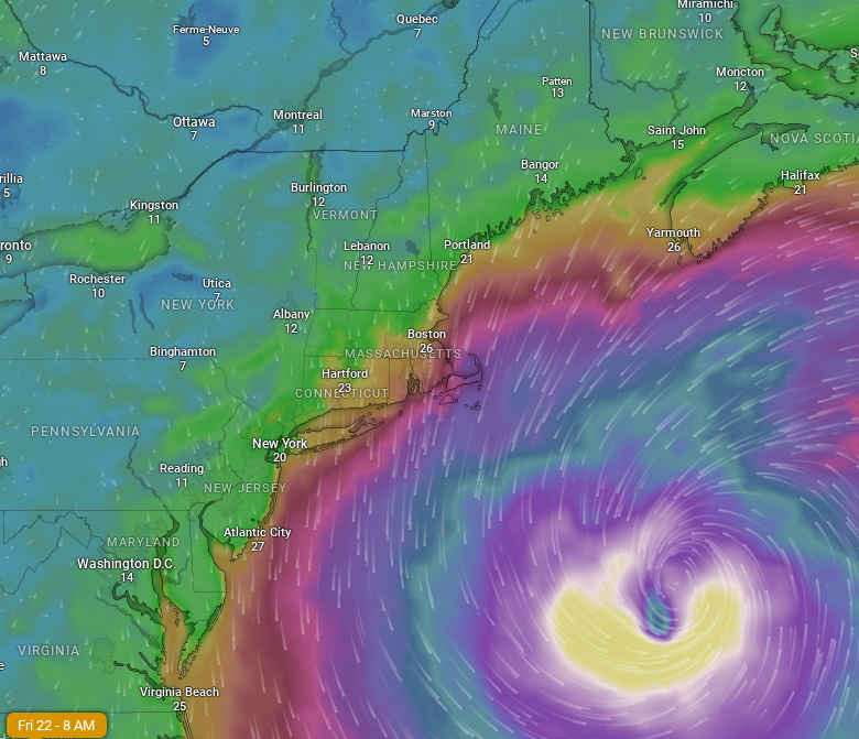
Hurricane Erin will make its closest pass to New England late Thursday into Friday. The departing trough from midweek and high pressure to New England's north will be the main factors keeping Erin well out to sea. The storm will pass about 450-500 miles away from New England's coastline. It will come just close enough to create some windy conditions across southeast Massachusetts. This increased wind will come due to the tight pressure gradient between Erin's low pressure and the high pressure to New England's north.
Below: Euro showing potential wind gusts Friday morning:

This week's high pressure will likely break down this weekend as a trough pushes north of New England. This system will eventually drag its cold front across the region, bringing a period of scattered thunderstorms. As of now, this is favored to occur on Sunday afternoon as high pressure still looks to hold for Saturday. With that said, the cold front has been trending later and now looks to cross New England next Monday rather than Sunday. This front will have the chance to bring a widespread rainfall and thunderstorms on Monday.
With that said, timing of the front is uncertain, especially as Erin continues to churn in the Atlantic. Hurricanes swirling in the Atlantic can have a large impact on the movement of other features across the United States, so timing this front is very difficult to do right now. Exact rainfall amounts and the placement of the most rain is also uncertain.


Comments