Troughing Dominates New England's Weather to Round Out Meteorological Summer
- Tim Dennis
- Aug 27
- 3 min read
General troughing will become centered over New England today, with a cold pool of air aloft. This will allow for plenty of cloud development today along with a few spot showers. These showers could pop up anywhere in New England today, but the air mass is pretty dry, so shower activity will remain very spotty. The cold air aloft combined with afternoon heating may provide just enough instability for a very quick thunderstorm. While the severe threat is almost zero today, the cold pool of air could support small hail or graupel for a brief time in some showers.
Below: 500mb height anomaly today, showing the general troughing in place over the northeast:

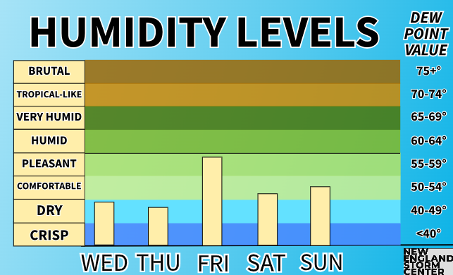
The dry air mass and cool temperatures will come with low humidity as well, similar to last week. There once again won't be a feeling of humidity at all in the air through the middle of the week. This will also allow overnight lows to drop off with cool nighttime temperatures once again. Overnight lows tonight will drop into the 40s to low 50s for most. Given the setup, the cold hollows of northern New England could see upper 30s Thursday morning.
While today may see some spotty shower activity, New England’s next shot at widespread precipitation will come on Friday, in the form of another cold front. An upper-level low will likely travel north of New England, dragging its cold front across the region. This system will be slowed down by another system well offshore. This will allow for moisture to stream into New England ahead of the front and allow for a period of more widespread rainfall.

The upper-level low will likely slow way down or stall just to New England's north, allowing for the showers to pinwheel around the system's cold front from west to east. Scattered showers will likely begin to break out from across western New England in the morning before slowly spreading east and becoming more widespread by the afternoon. Showers will likely continue to pinwheel into New England through the day with widespread activity arriving in eastern Maine by Friday night.
Below: RGEM showing potential weather Friday afternoon (1st image) and Friday night (2nd image):
While it’s unlikely to be an all day washout, a majority of New England will likely see showers and thunderstorms at some point Friday, resulting in a widespread quarter to three quarters of an inch of rain. A narrow ribbon of elevated moisture is expected to develop ahead of the front, and where this sets up in the afternoon will likely see the most rainfall out of this system. As of now, this is most likely to set up across central Massachusetts and into interior New Hampshire and Maine. At this point, an inch or more of rain will be difficult to see, and would be contingent on thunderstorms developing.

At this point, severe storm potential looks low as instability will likely be hard to build with a thick cloud cover in place for much of the day. With that said, shear will be modest and a strong southwest flow will be in place. In addition, CAPE values may be able to build to around 1,000. This is a situation where the large-scale dynamics may be able to offset the low instability and allow for a few stronger storms. While the severe threat is low as of now, the trends will be worth watching.
The upper-level low will likely remain parked just to New England's north for much of Saturday. The system's front may not clear eastern Maine until later Saturday morning. This will keep the showers around for eastern Maine through the day Saturday while the rest of New England begins to dry out. Overall, Saturday could end up similar to Wednesday for much of New England. High pressure will be trying to nudge back into New England in the wake of the frontal passage, aiding in conditions drying out Saturday for most.

Overall, troughing will continue to dominate New England's weather for much of the next week. This will keep temperatures on the lower end for the time of year with 70s dominating for much of the region. Humidity will also remain at a minimum. The one exception to this will be a stream of moisture on Friday ahead of the front, but any building humidity will be erased quickly by the passage of the front.


Comments