Two Storms on Tap This Week for New England
- Tim Dennis
- Dec 8, 2024
- 4 min read

After Sunday morning's bout of light snowfall, New England will have two more waves of precipitation coming through to continue this rather unsettled stretch. The first of these two will enter into western New England Monday afternoon and continue to move east through Tuesday. The second, much more organized system, will move into the region Tuesday night and continue through much of Wednesday. These systems will bring New England a mixed bag of precipitation.
The system coming later on Monday will be another case of precipitation breaking out along a warm front as warmer air moves into the region. The main difference with this one as opposed to Sunday morning is that temperatures will generally be warmer at the start. This will allow more by way of plain rain and mixing. This system will likely bring a mixed bag of rain, snow, freezing rain and sleet across the region.

Areas that are above freezing at the start of the event on Monday evening will see all rain showers. This will primarily be Connecticut, Rhode Island and eastern Massachusetts. Areas farther north and at higher elevations will likely see some mixing or a period of freezing rain. This will come as the warm front advects warmer air into the region aloft while temperatures at the surface remain below freezing for a time.
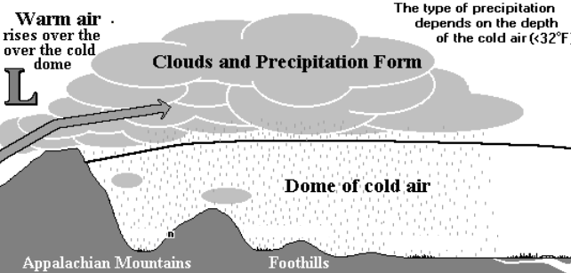
This will be especially true in mountain valleys, where cold air damming may come into play. Cold air damming occurs when a low-level cold air mass basically gets trapped by the mountains. With a warm nose of air rising aloft, it can lead to a period of freezing rain with warm air across the mid-levels and cold air remaining at the lower levels.
Below: Diagram of cold air damming:
The northern third of New England may see mostly snow showers as the warm front struggles to reach. With this system being associated with a warm front, moisture will be on the lower end, so accumulations of rain, ice and snow are all expected to be light. The bulk of precipitation is expected from Monday evening to Tuesday morning region-wide. Isolated showers may continue throughout Tuesday, but a majority of the afternoon is looking dry at this time.
Below: GFS showing potential weather very early Tuesday morning:

When all is said and done with this system, it will be a minor one, but a messy one, with all precipitation types possible at some point across New England. Snow accumulations across the north are currently expected to remain at a couple inches or less with ice accretion remaining lower than a tenth of an inch. Rain is expected to be around a quarter to maybe half an inch in areas that see rain the whole time.
Below: Probability of seeing at least an inch of snow by Tuesday evening (1st image) and probability of seeing at least a glaze of ice by Wednesday morning (2nd image):


This warm frontal passage will bring a reinforcing shot of milder air, which will help set the stage for our next, more potent storm system coming Tuesday night through Wednesday. A strengthening cold front will approach New England ahead of a trough over the Great Lakes. A surface low pressure system will likely form along this front across the southeast and move northward through New England.

This will set the stage for an organized storm system, bringing potentially bouts of moderate to heavy precipitation. As of now, guidance generally favors a winter washout storm for most, with rain dominating precipitation type for many. With that said, a flip snow on the backside remains possible. Moisture will be abundant with this system, with QPF in the 1.5 to 2.5 inch range for Wednesday. This is what will drive potential bouts of heavier rainfall.
While the region remains in a drought, this system could produce heavy enough rainfall rates to create excessive rain in the short term despite the ongoing drought conditions. This will help the drought in the long term. The Weather Prediction Center still has eastern New England in a "slight" risk (level 2 of 4) for excessive rainfall on Wednesday. Bouts of heavier rainfall could combine with melting snow across the north for some runoff issues. The extent of this remains to be seen.
Below: Weather Prediction Center current excessive rainfall outlook for Wednesday:

The track of the surface low through New England will determine the extent of wintry precipitation on the backside. The farther east the system tracks, the quicker a switchover may happen for western New England and the higher terrain. Eastern areas are currently favored to see mainly rain from beginning to end by all guidance, though trends will still need to be watched.
Below: Euro (1st image) and GFS (2nd image) model runs from Sunday morning for the end of the storm. You can see a more aggressive flip by the GFS. Both show rain at the start (and middle) of the event for everyone:


Convergence along the front will stretch across the Appalachian Mountains and into the southeast with this system. This will give the system a clear connection to the Gulf of Mexico, which always enhances the potential for heavier precipitation in New England, should other factors line up.
Below: Precipitable water values showing moisture streaming northward from the Gulf of Mexico:


Comments