Typical Seasonal Transition Weather is in Store for New England
- Tim Dennis
- Sep 18
- 3 min read

Typical seasonal transition weather is in store for New England, with multiple ups and downs through the next week or so (as one would generally expect in mid-September). A trough will slide across southern Canada later today into Friday. This will drag a cold front across New England. Return flow from the south will develop ahead of the front (as per usual), bringing a bout of warmer weather region-wide. Today will be a milder day for everyone across the region.
The cold front itself will likely zip through New England during the day Friday. The front will likely be pushing across southern New England through the afternoon, but it will take some time for the cooler air to make it down to the surface, so another milder day is on tap for southern and central New England. The passage will likely occur very early in the day for northernmost New England, allowing for a much cooler day.

The moisture-rich southern stream storm track will remain well south of New England, so low pressure formation or increased moisture along this frontal boundary is not expected. With that said, it will likely be a mainly dry passage. With the instability of a changing air mass, there will be a chance for spotty showers as it crosses, but nothing worth writing home about. In fact, there may be increased fire weather concerns with a dry frontal passage, dry fuels and some wind from the front.

By Saturday, the cold front will have cleared New England and the entire region will be under a cooler air mass. High pressure will build in behind the front, bringing dry weather with a very autumn feel in the air. Highs in the 60s will likely dominate across the entire region. The high pressure building in will originate from the Arctic, bringing these much cooler temperatures. Even the typically warmer Connecticut River Valley may struggle to reach the 70° mark.
Below; CMC showing potential temperatures Saturday afternoon:

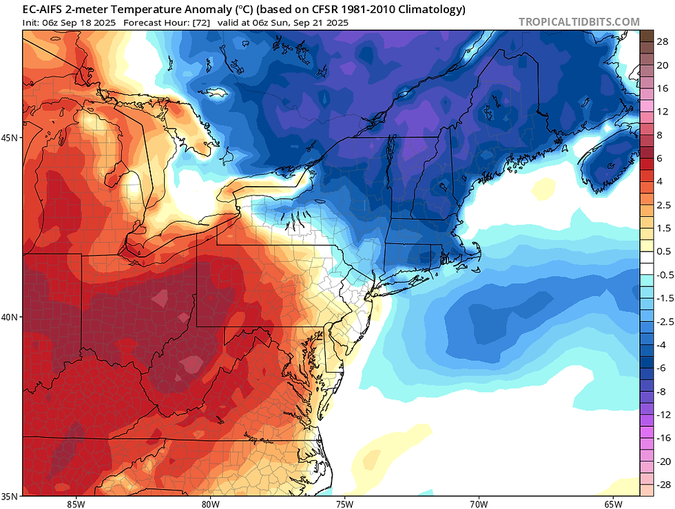
The center of this area of high pressure will move overhead during the day Saturday and continue to slide southeastward into Sunday. It is looking increasingly likely that the high pressure will be directly overhead of northern New England Saturday night, which will be when temperatures bottom out. Widespread lows in the mid 30s north to mid 40s south will be likely. The region's first widespread frost is possible, with some freezes across northernmost areas. Friday night and Sunday nights will be chilly, as well.
Below: Temperature departure from average early Sunday morning:
Looking ahead, this chilly weekend weather will likely be quickly replaced with a warming trend. Strong ridging will be in place over eastern Canada at the start of next week. Above average heights and warm temperatures aloft are expected to spill into much of the United States. The highest chance for above average temperatures will be across the north, closer to Canada's ridge. It continues to look like next Tuesday (September 23) will be the peak of the warmth.
We won't go as far to call it a "second summer", but the start of astronomical fall is currently looking rather mild. The one issue with this would be the presence of a negative NAO, which would make it more difficult for a firm ridge to develop over the east. This could put a damper on warmer weather, with some cooler weather quickly following. With that said, uncertainty remains on just how mild it could get next week (and how long it could last).

This negative NAO pattern may support the chances for some disturbances to slide through around midweek next week. This represents New England's next best chance at some showers. At this point, there's a decently large spread in how much rain could fall, but, at present, it doesn't look like too much. As expected, extreme drought status has expanded across the White Mountains region and into western Maine.
Below: Current US drought monitor (today's update):


Comments