Warm, Muggy Weekend for New England with Some Storms Possible
- Tim Dennis
- Jul 12
- 3 min read

High pressure will remain offshore of New England on Saturday. This will bring rising heights and a building ridge to New England. Despite this, some energy rotating around the ridge along with building instability and high moisture will promote some isolated to scattered storm development in the afternoon, especially for western parts of the region.
Below: FV3 showing potential weather late this afternoon:

The threat for strong to severe storms remains low across New England today. While plenty of moisture remains available for storms and modest instability will build, shear will be very limited, which is the main factor that can propel storms into severe storms. Lift and forcing will also be weak without a defined low pressure system or front over the region. Any storm activity will likely be driven by lift from terrain, so mountains, foothills and adjacent valleys will have the best chance to see activity.
The atmosphere does remain moisture-rich, so heavy downpours will remain possible within any storms. Weak forcing and flow may promote slow-moving storms, which will need to be watched, especially if a storm moves through an area that has seen multiple inches of rain over the past couple days. There's been little change in the atmosphere over New England today from yesterday, and some storms last evening dropped 2-4 inches of rain within a couple hours, so something similar could occur today.

There will once again be little change in the overall setup for Sunday. High pressure will remain offshore with a mid-level ridge in place. This will keep much of New England dry on Sunday as storm chances will generally be lower than Saturday. A cold front will be moving eastward out of the Great Lakes and into New York during the day. The ridge offshore will slow this front's eastward progress, however.

The timing of this system still has the severe weather/flash flooding impacts centered over New York rather than western New England Sunday afternoon and evening. A majority of New England will remain dry, however, some of this storm activity could spill into westernmost New England later in the day. This would most likely occur across northern Vermont.
Below: FV3 showing potential weather around mid-afternoon Sunday:

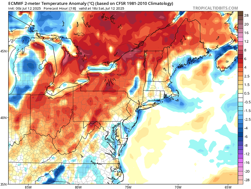
As for temperatures and humidity this weekend, little change in the overall setup will lead to more of the same. Generally seasonable temperatures are expected, with highs gradually becoming warmer as you make your way away from the ocean. A more southerly flow will continue to increase through the weekend, however, with high pressure offshore, an easterly influence will remain in place, which will keep temperatures in check for the coastal plain.
Below: Temperature departure from average this afternoon:
On Monday, the cold front will slowly push through New England, bringing a better chance at more widespread shower and storm activity across New England. This front will provide stronger lift for storms, but the front will be weakening as it pushes eastward. Marginal instability and weak shear will continue to keep the threat of severe storms lower. The exact timing of the front will determine if there's a chance for a few stronger storms or if they all remain "garden-variety".

The bigger threat will continue to be the potential for heavy downpours within storms. With a slow-moving front and a rather weak wind fields, storms may once again be rather slow-moving. Moisture will pool ahead of the front, setting the stage for the potential for heavy rainfall rates. If some areas end up receiving bouts of heavier rain this weekend, the flash flood threat would increase for Monday.
Heading toward the middle of next week, a ridge will build over the eastern United States, leading to increasing heat and humidity. How much moisture rides over the ridge will determine what the humidity levels will be, which will determine feels-like temperatures. As of now, heat index values in the mid 90s to low 100s will be possible for the typical warm spots in the region (Merrimack Valley, Connecticut River Valley and Champlain Valley). This heat wave will likely end late next week with the passage of a cold front.


Comments